Keep Victoria Falls Wild
Conservation and Development of the Victoria Falls
The 2001 Combination Plan
The Abandoned Plan (2001)
The Riparian Fringe
Permanent Protection?
A Question of Management
Fall and Rise (2001-6)
The Legacy Development (2006)
Development Moratorium (2007-8)
World’s Largest Conservation Area (2006)
The following text has been adapted (with permission) from
researched and written by Peter Roberts and published in February 2026
The 2001 Combination Plan
The Abandoned Plan (2001)
Progress towards a combined ‘Master Plan’ for the management of development on the south bank was initiated in 1999 with funding from the Canadian Government and resulting in the publication of an extensive draft study report in June 2001 known as the Combination Master Plan (Plan Afric, 2001). The study area covered an area within a 30 km radius of the Falls on the south bank of the river. Unfortunately the funding was withdrawn as a result of political instabilities in Zimbabwe and the process was abandoned.
A review of the Council controlled area found the are to be just over 2,170 hectares (21.7 km²), a reduction from the 1975 figure (which included the area between the Railway Loop and Zambezi Drive road and which has subsequently been confirmed as being under National Park control).
“The total land area of the Municipality has recently been surveyed and given as 2,170.58 ha. This varies from the figures used in the 1975 Outline Plan by about 41 ha. This may be explained by the inclusion in the Outline Plan of land along the River Zambezi that was included for planning purposes but was outside the Municipal boundary.” (Plan Afric, 2001, p.79)
The Plan noted that the Zimbabwe National Park Authority were restricted in the degazetting of land under the Parks estate and only permitted in exchange for a similar area land of equal or greater conservation value.
“An additional aspect of National Park legislation is that it is prohibited to dispose of more than 1% of National Parks lands and generally, if National Parks do cede any land they require a quid pro quo to restore the balance.” (Plan Afric, 2001, p.21)
The Plan indicated the successful de-mining of the minefield zones which had surrounded the town since the late 1970s independence struggles.
The Riparian Fringe
The Plan noted the importance, and vulnerability, of the riparian fringe vegetation:
“This vegetation type occurs along the upper Zambezi River, with some outliers (often only a few species) around the springs. Although very limited in extent, the riverine woodlands are the most attractive to tourists, both for their aesthetic value and their diversity. The riparian vegetation is also vital to riverbank stability. The type is characterised by tall, evergreen trees forming a discontinuous canopy on loamy alluvial soils of the old river terraces, a strip 20-100m wide. The fertile soils and proximity to water give rise to a diversity of plant and anumal species. Diospyros mespiliformis, Garcinia livingstonei, Trichilia emetica, Acacia nigescans and Syzigium guineense ssp. Barotsence and S cordatum are the common tree species. Syzgium is one of the key stabilisers of the riverbank. The shrub under-storey is well developed and climbers such as Artabotrys brachypetala are common. There are also scattered clumps of the ilala palms Hyphaene ventricosa and Phoenix reclinata palms. Grasses are short-medium height perennials with high forage value and many riparian tree species produce fruits that are eaten by birds and mammals; the area is consequently heavily utilised by wildlife...
“The riparian woodlands are seriously threatened by elephant damage, particularly the section from the Rain Forest upstream to the A’Zambezi. A field check revealed numerous tall trees pushed over by elepehants, and according Mr T Muller (botanist), at least two shrub species are no longer found in this area because of elephant pressure; Croton leuconeurus and Homalium abdessammadii. Also Garcinia livingstonei, once a common riverine tree, is now rare.
“It is worth noting that as early as 1969 Hill found severe deterioration of the riparian woodlands through elephant damage and was alarmed by the lack of regeneration of targeted species. Although no data were available, given the increase in elephant populations since 1969, the present situation must be considerably worse.
“The Rain Forest is included in this type as it is simply an extension of riparian woodland. Here Syzgium and P reclinata are the most common species, with Mumusops zeyheri, Ficus sur and F thonninhii. Langman (1978) found that Syzgium tends to dominate the area because of its shallow rooting and ability to reproduce vegetatively... This obviously has implication for any planned replanting of trees. Botanically the herbaceous plants in the Rain Forest are the most important as several are possibly endemic (Fanshawe, 1990). Since there is no up to date checklist available, nor an extant herbarium, it was not possible to check which of the plants listed by Wild (1964) are still present. Tourist pressure (trampling, picking plants) may have lead to the loss of some species and this needs to be checked.
“Several stakeholders expressed concern about the invasion of the Rain Forest and riparian woodlands by Lantana camara. This noxious, highly invasive shrub colonises disturbed ground and is spread by frugivorous animals. It is out-competing indigenous shrubs and leading to a loss of wildlife habitat. Although National Parks have a control programme, the weed has continued to spread as the vegetation becomes more and more disturbed by elephant and human development.
“The islands in the Zambezi River are either sandbanks with clumps of Phragmites mauritanus reeds and Cyperus papyrus, with Salix subserrata and Syzygium trees, or basaltic rocky islands with deposits of sand and alluvium which support riparian forest and thicket. The islands are now an important refuge for birds and other animals that have been disturbed by human interference or destruction of the riparian habitat.” (Plan Afric, 2001, p.36-7)
Permanent Protection?
The Plan presented summary details of the 1975 Outline Plan (as per Heath, 1977), confirming the areas designated as Public and Private Open Space as being ‘restricted permanently against building development’ (Plan Afric, 2001, p.15). This status appears to be overlooked later in the document, which only recognised the protected status of the land stretching east from the town towards the Falls, including the Railway Loop, Zambezi Drive and Rainforest.
“An important category of Open Space, established under the Outline Plan, is a protected area of Public Open Space that is part managed by the DNPWLM and part by the Municipality. The DNPWLM is responsible for the Victoria Falls and Rain Forest area, which is accessible on payment of a fee, and a strip of land along the river Zambezi, which is accessible without charge. The Municipality has responsibility for land, which runs from the Victoria Falls and Rain Forest to the Town Centre and embraces an area known as the Railway Loop. It is also responsible for land either side of the circular road that links the town centre, the large Baobab Tree and circumvents the Ran Forest area. This is an area of wildlife, with a small buffalo herd and many smaller antelope and mammals as well as occasional elephants. The railway loop has been partly eroded from the south by commercial activities, the latest of which is the establishment of the Helium Balloon.”
The remaining protected area is described without directly referencing its protected status.
“A further area of Public Open Space, for which the Municipality is responsible, is the area that lies north of Park Way, from opposite Inyathi Lodge to the Zambezi Camp site. This area abuts the Golf Course. It is a generally flat area of sparse vegetation that has resident populations of impala and other antelope, as well as small mammals, such as warthogs and acts as a game corridor for the larger animals seeking to reach the river Zambezi.” (Plan Afric, 2001, p.84)
The Plan identifies 345 hectares (3.45 km²) of land as ‘unsuitable’ for development due to ‘constraints’, identified as physical features such as rugged areas susceptible to erosion (86 ha/0.86 km²) and also including ‘environmentally sensitive’ areas (259 ha/2.59 km²).
“The final category of land includes all that land that appears to be difficult to develop due to slopes and other rugged features. If such land were attempted to be developed it would result in potential serious erosion. It also includes areas that are probably too sensitive to develop due to their proximity to very attractive and important environmental features, such as the Zambezi River or areas commanding important vistas.” (Plan Afric, 2001, p.94)
Of the 259 hectares (2.59 km²) described as ‘environmentally sensitive’ only 77 ha (0.77 km²) is specifically identified within the Plan (identified as Areas 11, 12 and 14) covering the area stretching east from the town centre to the Falls. Notably the wording indicates the area as being ‘currently’ protected, rather than permanently, under the 1975 Plan (a status given to Rural Land under the 1975 Plan):
“[11] Area between Railway Loop and River Zambezi, bordering the Rain Forest to South (38 ha) - Riverine, attractive area. Protected currently under the Outline Plan against development.
“[12] Area within the Railway Loop (28 ha) - Good vegetation, wildlife. Incursions from south from commercial operations. Protected currently under the Outline Plan against development.
“[14] Between Railway, Kingdom Hotel, main road and Municipal Boundary (11 ha) - Attractive area close to Zambezi. Protected currently under the Outline Plan against development.” (Plan Afric, 2001, p.91)
The total of 259 hectares (2.59 km²) also included 59 ha (0.56 km²) of the riverine fringe protected under the National Park Authority as being within the environmentally sensitive/permanently protected area, bringing the total area identified to 136 ha (1.66 km²).
“[33] DNPWLM land along the River Zambezi, including the Falls and Rain Forest area (59 ha). Protected from development, both as part of the Parks estate and in the Outline Plan.” (Plan Afric, 2001, p.93)
The remaining 123 hectares (1.23 km²) is described only as ‘Other Areas’ without being specifically identified (Plan Afric, 2001, p.95). A detailed breakdown of undeveloped land is however given within the context of development opportunities, and Areas 4, 5, 6 and 7, totalling 97 ha (0.97 km²) can be determined as being part of the remaining 123 ha (1.23 km²) of ‘environmentally sensitive’ - and permanently protected - land.
“4. Between Camp site/proposed Fish Farm and E Hills Golf Course and Park Way (28 ha). Flat terrain near to River Zambezi. Traversed by River Safari Companies accessing jetties and also access to Water intake pump house. Overlooked by Elephant Hills Hotel.
5. Between Elephant Hills access roads and Park Way (5 ha). Rugged area.
6. North of Park Way to Elephant Hills Hotel and Golf Course (56 ha). Rugged near to Elephant Hills Kopje site, then very flat terrain crossed by numerous small streams. Important animal crossing area. Has one small temporary construction depot and a football pitch.
7. Between Park Way, Baobab Road and Golf Course (8 ha). Relatively flat, part riverine vegetation. Temporary Gardini Camp. Extent of Golf Course not clear.” (Plan Afric, 2001, p.90)
The areas detailed above leaves 26 ha (0.26 km²) of ‘environmentally sensitive’ land identified within the total of 259 ha (2.59 km²) but not specified in terms of location. This area is believed to be accounted for by the remaining riverside stands stretching upstream to the Zambezi National Park Boundary, including the A’Zambezi Lodge and abandoned Zambezi Camp site.
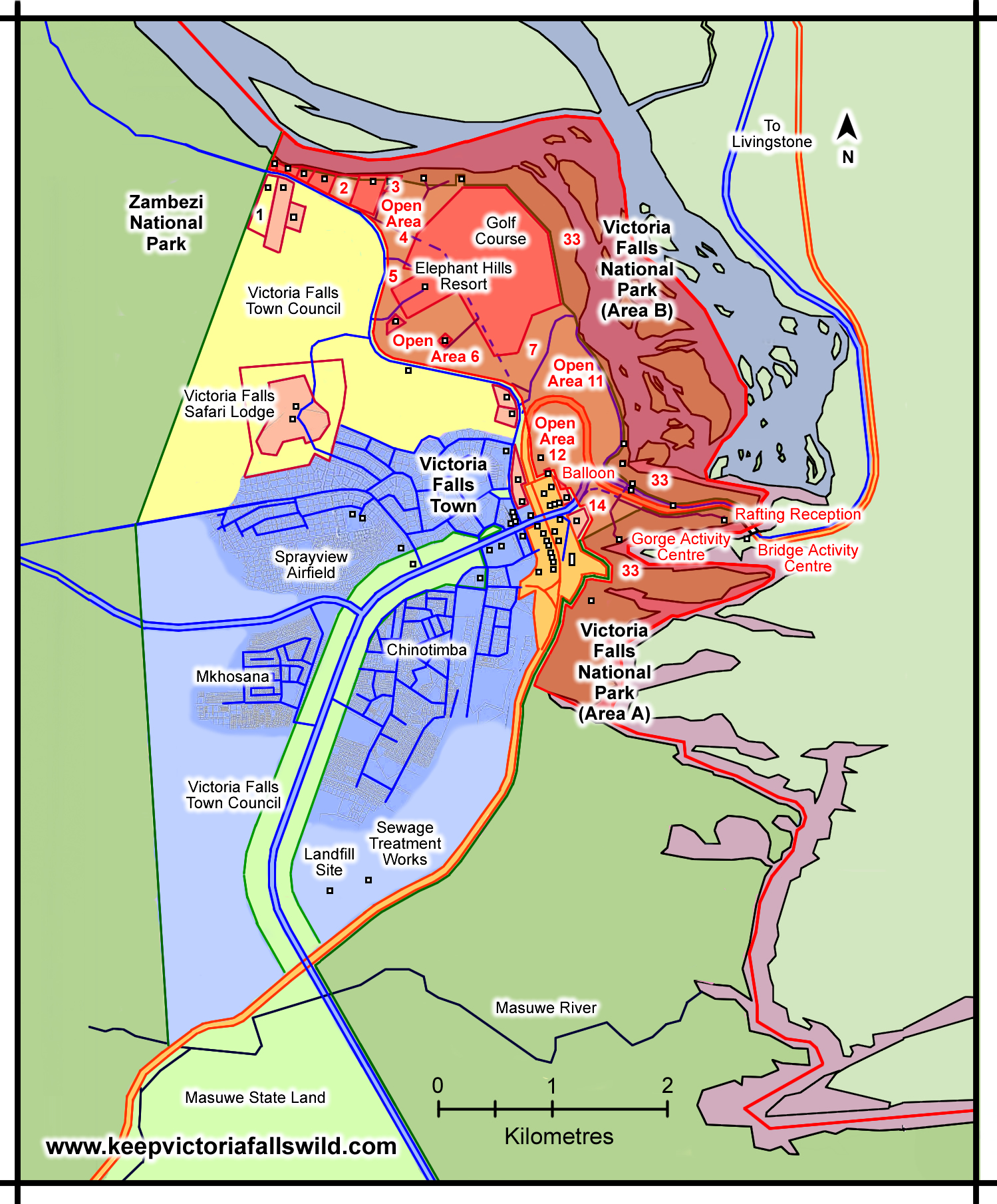
Developments at the Victoria Falls during the early 2000s, showing Open Land
Areas (shaded in red, numbered) designated as permanently protected under the
1975 Outline Plan. New developments within this area since the 1996 Plan in red.
(Adapted from Plan Afric, 2001, Map 36)
[click image for larger view].
A Question of Management
The Plan also highlighted a lack of monitoring and reporting on the site from the State Parties, as required by the World Heritage Committee.
“Over the past decade the [Zimbabwean] Department of National Parks and Wildlife Management have reportedly not been meeting these obligations either for Victoria Falls or Mana Pools, which is also inscribed. Now there is some confusion regarding who should be the management authority for the [south bank section of the] WHS (National Museums and Monuments are reportedly interested in taking this role.)... It is urgent that these matters are resolved and that Zimbabwe, together with Zambia who are co-proposers, meet their obligations as State Parties.” (Plan Afric, 2001, p.60)
The question of National Museums and Monuments of Zimbabwe’s management of the south bank visitor area remained an unresolved issue.
“Although the Falls and associated Rain Forest is indisputably a declared National Monument the administration of the area has remained with the DNPWLM since the 1950s, as part of the Parks estate. Recently the NMMZ Board of Trustees has sought to assume its responsibility for the management of the area and this has been resisted by the DNPWLM. The dispute is currently before the Cabinet for a decision.” (Plan Afric, 2001, p.21-2)
Independent Authority (2001)
The Zimbabwe Department of National Parks and Wildlife Management became a independent self-funding authority, the Zimbabwe Parks and Wildlife Management Authority (also known as 'ZimParks') under the Parks and Wildlife Act of 1996 (Chapter 20:14), amended by Act Number 19 of 2001. Tourism revenues generated by visitors to the Falls provide a significant percentage of the Authority's annual income, with funds supporting the Authority's work across the country. The new Authority fell under the responsibility of the Ministry of Environment, Climate Change, Tourism and Hospitality Industry.
Today the Victoria Falls National Park includes the immediate area of the Falls Rainforest with a narrow strip of riverine fringe extending six kilometres upstream (436 ha) and a downstream area (1,904 ha) covering the gorges stretching some 12 kilometres downstream, separated by the road and rail transport corridor which crosses over the Victoria Falls Bridge immediately below the Falls. With a total area of 2,340 hectares (23.4 km2) it is one of the smallest National Parks in the world. The upstream Zambezi National Park extends over 56,010 hectares (just over 560 km2).
Fall and Rise (2001-6)
Visitor arrivals to Zimbabwe, which had recovered to 2,217,429 in 2001, dropped to 2,041,202 in 2002. Overseas arrivals dropped significantly from 480,243 to 281,105 in 2002. The Falls Rainforest recorded only 47,525 visitors in 2001, including just 14,787 international visitors, with figures recovering to 88,098 including 26,612 international visitors in 2002. Average room occupancy in the Falls fell only slightly from 43 percent in 2001 to 41 percent in 2002 (Mugwati, Nkala and Mashiri, 2016).
In 2001 the town’s eight main hotels, several lodges and numerous guest houses were estimated to be able accommodate a capacity of about 3,000 visitor bednights, with the town calculated to cover an area of 2,212 hectares (PlanAfric, 2001). Victoria Falls Town attained municipality status in 1999 and by 2002 the population had grown to 31,375 residents (Central Statistics Office, 2002).
International arrivals recovered to new record highs of 2,256,205 in 2003 before falling to 1,854,488 in 2004, with overseas visitors rising from 312,601 to 330,797 over the same period. Arrivals from Asia peaked at 66,804 visitors in 2004.
The Falls Rainforest recorded 93,991 visitors in 2003, including 46,641 international visitors, with figures recovering to 128,963 visitors in 2004, including 78,644 international visitors. Average room occupancy in the Falls fell from 35 percent in 2003 to 29 percent in 2004 (Mugwati, Nkala and Mashiri, 2016).
In 2004 visitors exploring the Zambian side of the Falls totalled 72,002, including 31,227 international visitors. Political and economic uncertainty south of the river resulted in this figure jumping to 179,786 in 2005, with a record number of 73,044 international visitors. In 2006 numbers decreased dramatically, with a total of 109,424 visitors with only 36,792 international visitors (Zambian Ministry of Tourism and Arts, 2014).
International arrivals to Zimbabwe fell to 1,558,500 in 2005. Visitors to the Falls Rainforest totalled 161,834 in 2005, declining to 134,010 in 2006 (World Heritage Committee, 2007). Average hotel room occupancy on the south bank of the Falls rose from 31 percent in 2005 to 38 percent in 2006 before dropping to 34 percent in 2007.
The Legacy Development (2006)
In October 2006 it was announced that the Zambian Wildlife Authority (ZAWA) had awarded a 75-year land lease to the Legacy Zambia Holdings for a major new tourism development on the north bank a short distance above the Falls. The proposed $200 million Mosi-oa-Tunya Hotel and Country Club Estate Project included two five-star hotels (with over 450 rooms), an 18-hole golf course, conference centre and a marina on a 550 acre riverside site in the Mosi-oa-Tunya National Park, including an area within the World Heritage Site. The Legacy development proposals resulted in widespread negative reaction, including critical comments from the World Hertiage Committee and stimulating a second UNESCO Monitoring Mission to the site in November 2006, before being abandoned.
The Mission resulted in a moratorium on all new developments within the WHS pending completion of a Joint Management Plan for the Site (submitted in 2007).
Development Moratorium (2007-8)
A moratorium on development within and surrounding the World Heritage Site was subsequently requested by UNESCO, pending agreement and implementation of a Joint Management Plan for the site between the two State Parties, agreed in 2002 but yet to be drafted. The moratorium was implemented on both sides of the river in January 2007. Media reports quoted Dr Mutsambiwa, Zimbabwe National Park Authority Director-General reflecting:
“This plan was supposed to have been in place before Zambia had started building a hot air balloon base and a 500-bed lodge. We were also expected to monitor all activities on our side and some developments were overlooked. We were very much concerned because this meant that the tourist attraction could be de-listed from its World Heritage Status. This would be a shame to us because we presented this area as deserving such a status. To try and regain that status, if it happens that we lose it, would actually be almost impossible.” (Victoria Falls Bits and Blogs, 24th January 2007)
World’s Largest Conservation Area (2006)
The Kavango-Zambezi Transfrontier Conservation Area (KAZA TFCA) is a cooperative effort among five neighbouring countries - Angola, Botswana, Namibia, Zambia and Zimbabwe - to link protected wildlife areas across international boundaries. The Victoria Falls is at the heart of the TFCA near the meeting point of four of the five participating countries on the Zambezi at Kazungula.
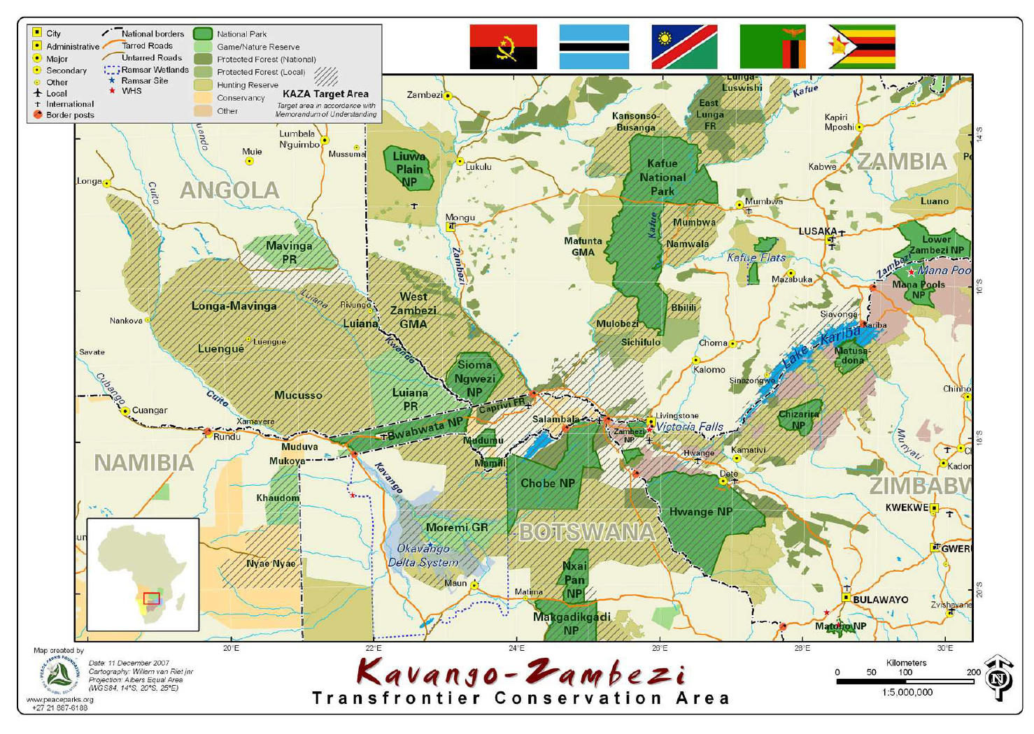
Kavango-Zambezi Transfrontier Conservation Area (KAZA TFCA)
[click image for larger view].
This vast wilderness and wildlife area is the world’s largest transfrontier conservation project at approximately 520,000 square kilometres, a size rivalling that of France. Occupying the Okavango and Zambezi river basins, it includes 17 national parks and a host of game reserves, forest reserves, game management areas, wildlife conservation and tourism concession reserves.
The region supports the largest contiguous population of African elephant, with more than 120,000 elephants recorded in recent aerial surveys from the Okavango/Chobe region, over 50,000 elephants in north-western Zimbabwe and 16,000 in north-eastern Namibia. Other focal species of conservation concern across the region include important populations of wild dog, lion and cheetah.
The TFCA was declared in 2006 with the signing of a Memorandum of Understanding between the five participating countries, followed by the signing of a formal Treaty in 2011 through which the park was legally established. The KAZA TFCA records its mission to ‘establish a world-class transfrontier conservation area and tourism destination in the Okavango and Zambezi river basin regions of Angola, Botswana, Namibia, Zambia and Zimbabwe within the context of sustainable development.’
A survey of tourism accommodation provision in the KAZA region, undertaken over 2004, estimated a bed-night capacity of 8,312 and a total annual guest-night figure of 782,200. Tourism revenues were estimated at over $100 million, with $89.4 million generated within the accommodation sector and $10.8 million by tour operators. Of the available accommodation capacity, 35 percent was in Livingstone, 32 percent in Victoria Falls, 17 percent in northern Botswana, 12 percent in Caprivi and just four percent along the Upper Zambezi.
“It is estimated that just over... 782,200 bed-nights were sold in the region. Livingstone made 39 percent of total KAZA TFCA sales, Victoria Falls made 25 percent, northern Botswana [Chobe] made 23 percent, Caprivi sold nine percent of total bed-nights and establishments along the Upper Zambezi sold the remaining four percent.” (Suich, Busch and Barbancho, 2005)
Next: The 2007 Joint Plan
References
Links to external sites or pdf downloads, open in a new window.
Central Statistics Office (2002) Zimbabwe Census Report 2002, Central Statistics Office, Harare.
Mugwati, M, Nkala, D. and Mashiri, E. (2016) Experiences in the Zimbabwe Hotel Industry during Hyperinflation. [In Kararach, G. and Otieno, R. [Editors] (2016)]
Plan Afric (2001) Victoria Falls Combination Mater Plan. Draft Report of Study (pdf download [36.6 mb], opens in a new window)
Roberts, P. (2025) Footsteps Through Time - A History of Travel and Tourism to the Victoria Falls. Second Edition. Zambezi Book Company / CreateSpace Independent Publishing. (First published 2017, fourth edition July 2025).
Roberts, P. (2026) Paradise Lost? Conservation and Development of the Victoria Falls (1900-2025). First Edition, February 2026. Zambezi Book Company / CreateSpace Independent Publishing.
Victoria Falls Bits and Blogs (15th November 2006) Victoria Falls could lose World Heritage status.
World Heritage Committee (2007) Decisions Adopted, 31COM 7B.4 [Online
source: https://whc.unesco.org/en/soc/967]
Zambia Ministry of Tourism (2014) Tourism Statistical Digest 2013.