Keep Victoria Falls Wild
Existing Developments
Mosi-oa-Tunya National Park (Zambia)
Boundary Issues (2006)
Boundary Issues (2006)
Imusho Village (Upstream)
Songwe Village (Downstream)
Maramba Irregularities
Waterfront and Maramba Lodges
Boundary Issues (MoT, Dec 2006)
The area of the north-bank Mosi-oa-Tunya National Park within the WHS was originally identified as 3,779 hectares (State Parties, 2007, p.14) out of a total area of 6,900 ha and excluding the majority of the upstream section of the Park from the WHS. In 2006 physical mapping of the boundary on the ground revealed two areas of human-related incursion; an upstream village settlement located within the Park boundaries, and the encroachment of another village at the downstream end.
Legal amendments where made to the Park’s boundary to accommodate the resolutions to this issues, with Statutory Instrument No.112 (The Mosi-oa-Tunya National Park No.17 (Alteration of Boundaries) Order, 2006) adopted on 21st November 2006.
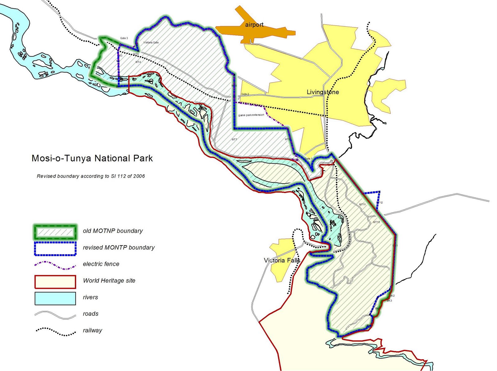
Map of the Mosi-oa-Tunya National Park 2006 boundary changes (Whitehead, 2007). [click for larger view]
The revised area of the Park was estimated at 6,555 ha. The corresponding revision to the area covered by WHS is unknown, with the changes yet to be formally submitted to UNESCO. A stakeholder workshop was held by National Parks in September 2006 to explain the issues and discuss the changes (Mateke, 2006).
Imusho Village (Upstream)
A historical anomaly had resulted in an upstream settlement, the site of Imusho village, being located within the upstream river section of the Mosi-oa-Tunya National Park. As part of the changes the village was relocated 1 km upstream to the extreme upstream end of the Park into an area which was subsequently degazetted (but still within the WHS).
“Imusho Village, which used to be between the former fenced area and Thorntree Lodge had been moved upriver of Thorntree Lodge, before Sinde River. To accommodate this move, the northern end of the park was to be degazetted and would now end at Thorntree, not at Sinde River.” (Mateke, 2006)
It was also announced that the old Imusho village site had been advertised as a riverside lodge tourism concession. The tender was won by Wilderness Tours Ltd, and a Tourism Concession Agreement had been signed and EIA in process.
Songwe Village (Downstream)
A small area of the downstream (south-eastern) section of the National Park, where it was proposed to move the boundary from the Songwe River to the road, where the village has spread into the Park.
“Apparently the villagers thought the boundary was the road and ZAWA has done nothing for years about checking their boundaries... The part of Songwe Village which has been removed from the [Mosi-os-Tunya] park is presumably still in the World Heritage Site.” (Whitehead, 2007)
In compensation, Chief Mukuni offered a triangle of land, covering approx 48 hectares, located further north to be incorporated within the Park.
Maramba Irregularities
The area of the north-bank Mosi-oa-Tunya National Park within the WHS was originally identified as 3,779 hectares (State Parties, 2007, p.14) out of a total area of 6,900 ha and excluding the majority of the upstream section of the Park from the WHS. In 2006 physical mapping of the boundary on the ground revealed two areas of human-related incursion; an upstream village settlement located within the Park boundaries, and the encroachment of another village at the downstream end. Legal amendments where made to the Park’s boundary to accommodate the resolutions to this issues, with Statutory Instrument No.112 (The Mosi-oa-Tunya National Park No.17 (Alteration of Boundaries) Order, 2006) adopted on 21st November 2006.
The boundary survey also revealed other irregularities, with the historic issuing of private land title deeds on properties which overlapped into the MTNP area, especially in the area of the Maramba River. From the Maramba River upstream the boundary of the MTNP extends 400m across the Maramba and then continues upstream along the Zambezi to connect with upstream section of the MTNP. This 400m riverside zone appears to not be included within the WHS, which follows the river-bank (high-water) line of the Maramba and then Zambezi River, with the 500m Buffer Zone extending away from the river.
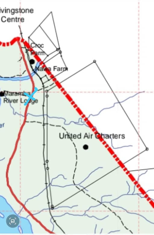
Map showing private stands overlapping into MoT NP.
[click for larger view]
Livingstone Crocodile Farm and stand identified as Nawa Farm both developed on private land the along Maramba River, adjoining and overlapping slightly into the area of the MTNP (Mateke, 2006). Nawa Farm, home to the Thorn Tree Lodge development, being on the southern side of the Maramba River is also partly within the WHS.
Another larger plot, the old Livingstone airfield, now under title to United Air Carriers, significantly overlaps into the MTNP and WHS.
“There is a large farm overlapping into the park, on which United Air Charters is situated... This tourism development was built on land under title belonging to the Mwiinga family. More than half of the plot was within the park.” (Mateke, 2006)
Waterfront and Maramba Lodges
In July 2007 it emerged that two further tourism developments had title deeds to land within the boundaries of the Mosi-oa-Tunya National Park.
“It was observed that two operators namely Waterfront Lodge and Maramba River Lodge had been issued with title deeds in the Mosi-oa-Tunya National Park. The title deeds for Waterfront have since been cancelled and a Tourism Concession Agreement was signed on 8th February 2005 for a period of twenty five (25) years. As of August 2006, the title deed for Maramba River Lodge had not been cancelled and the Authority was not receiving any money from the lodge, as there was no agreement though the lodge operated in the National Park. Furthermore, there was no evidence of an Environmental Impact Assessment having been done for the above-mentioned lodges by the ECZ.” (Victoria Falls Heritage Blogspot, 24th July 2007)

Area of Maramba River and surrounding developments (2025).
[click for larger view]
References
Mateke, C. (2006) Notes on Zambia Wildlife Authority (ZAWA) Stakeholders’ Workshop on the Preparation of the General Management Plan for Mosi-oa-Tunya National Park, 11-15 September 2006, New Fairmount Hotel, Livingstone. victoriafallsheritage.blogspot.com.
Roberts, P. (2025) Footsteps Through Time - A History of Travel and Tourism to the Victoria Falls. Second Edition. Zambezi Book Company / CreateSpace Independent Publishing. (First published 2017, fourth edition July 2025).
Victoria Falls Heritage Blogspot (24th July 2007) Irregular Issue of Title Deeds in Mosi-oa-Tunya National Park.
Whitehead, M. (2007) Notes on revision of Mosi-oa-Tunya National Park boundary by Margaret Whitehead, 12th February 2007. victoriafallsheritage.blogspot.com