Keep Victoria Falls Wild
Conservation and Development of the Victoria Falls
Batoka Gorge Hydro-Electric Scheme
Nothing to Declare?
Mosi-oa-Tunya Resort Mitigations
New Joint Plan Finalised?
Boundary Modification Requested
Modified Management Zones
Revised Boundary Description
Buffer Zone Issues
Missing Management Zones
Reaction and Recommendations
The following text has been adapted (with permission) from
researched and written by Peter Roberts and published in February 2026
The 2025 State of Conservation Report and
2025-2030 Joint Integrated Management Plan
At the end of December 2025 the State Parties of Zambia and Zimbabwe submitted a new State of Conservation Report for the UNESCO Victoria Falls World Heritage Site (State Parties, 2025a) together with the new 2025-2030 Draft Joint Integrated Management Plan for the Site (State Parties, 2025b). The documents were made available to download as a single file on the UNESCO website in mid-January 2026 (download here).
2025 State of Conservation Report
The 2025 State of Conservation Report, covering the period 2024-5, is dated and stamped on behalf of (but notably not signed by) Mr Kagosi Mwamulowe, Executive Director, National Heritage Conservation Commission, Zambia and Prof. Edson Gandiwa, Director General, Zimbabwe Parks and Wildlife Management Authority, Zimbabwe, on 1st December 2025.
In response to the World Heritage Committee’s Decisions recorded at the 46th World Heritage Committee Conference (46COM), held in New Delhi, India in July 2024, the State Parties emphasised their commitment to the World Heritage processes and implementation of the 2022 Reactive Monitoring Mission recommendations (World Heritiage Committee, 2023).
“Zambia and Zimbabwe reiterate their dedication to the full implementation of the 2022 Reactive Monitoring Mission (RMM) recommendations and will continue to work collaboratively to address all identified management and conservation priorities.” (State Parties, 2025a, p.5)
Batoka Gorge Hydro-Electric Scheme
Despite repeated confirmation of their commitment to the World Heritage process, the Report also confirms the State Parties joint commitment to the development of the Batoka Gorge Hydro-Electric Scheme, in direct conflict with World Heritage aims and values.
"The States Parties recognize the importance of safeguarding the property's Outstanding Universal Value (OUV) and confirm that the Environmental and Social Impact Assessment (ESIA) is being revised in accordance with the Guidance and Toolkit for Impact Assessments in a World Heritage context. The revised ESIA will include alternative scenarios designed to avoid any adverse impacts on the OUV of the property. The States Parties further affirm their commitment to submit the revised ESIA to the World Heritage Centre for review by IUCN prior to taking any decision that could be difficult to reverse, demonstrating their continued dedication to the conservation and sustainable management of the property.
The Zambezi River Authority (ZRA) and both States Parties commit to undertake the geomorphogical and geological baseline survey. The preliminary survey shall act as a baseline survey and further follow up surveys shall be undertaken bi-annually to determine any changes that may occur and possibly be attributed to the existence of the dam." (State Parties, 2025a, p.7)
Nothing to Declare?
As with other recent State of Conservation Reports there is no presentation of visitor numbers to the Site and no disclosure of recent developments which have already been agreed, constructed or implemented within the south-bank section of the WHS, including the significant redevelopment of the Wild Horizons Lookout Cafe, launch of an Abseil activity within the Rainforest, tours to Cataract Island (launched by Zambezi Crescent in 2022), the development of the Baines Restaurant (opened in mid-2023), the rapidly expanding National Park Rock Pool development, the proposed Six Senses riverside lodge development, the recent redevelopment of the Zambezi National Park lodges and take-over by Zambezi Crescent (rebranded as the Malachite Suites), significant expansion of the Zambezi Crescent operated Victoria Falls River Lodge and proposed development of Kandahar Camp - all of which have yet to be formally disclosed by the State Parties. All these developments are located within the World Heritage Site 'Highly Ecologically Sensitive Zone' (HESZ) which prevents all new infrastructure developments (with the exception of infrastructure essential to the management of the site).
Instead of disclosing the extent of this wave of illegitimate development within the WHS HESZ the State Parties have decided to yet again to keep UNESCO and the World Heritage Committee in the dark and simply report that there have been no 'new' development proposals.
“A number of development proposals have been submitted for consideration to be undertaken within the MoT/VFWHS and its’ buffer. The developments and activities have not been accepted by the Authorities from both State Parties, ZimParks and NHCC. As per requirement both by the environmental laws and the July 2025 Operational Guidelines of the 1972 WHC, these proposed developments have to undergo the Environmental and Heritage Impact Assessment (EHIA) process. The proposed developments described below are mostly at the scoping stage and the EIA documents have not yet been produced for evaluation by the management bodies...
“There are currently no accepted proposed activities within the World Heritage Property, ensuring that the site remains protected from potential developments that could impact its OUV.” (State Parties, 2025a, p.16)
The fact remains that despite all the statements and commitments by the State Parties to follow the Operational Guidelines, ZimParks have already entered into legal contracts for these developments, before making any disclosure to UNESCO or submitting ESIA documents for review, and that any comments or recommendations made by the World Heritage Committee will come after the approval the development has already been made (for example the Six Senses lodges and Kandahar Camp developments, where lease agreements have already been signed), or even after the developments have been constructed (Baines Restaurant, Rock Pool and Malachite Suite developments).
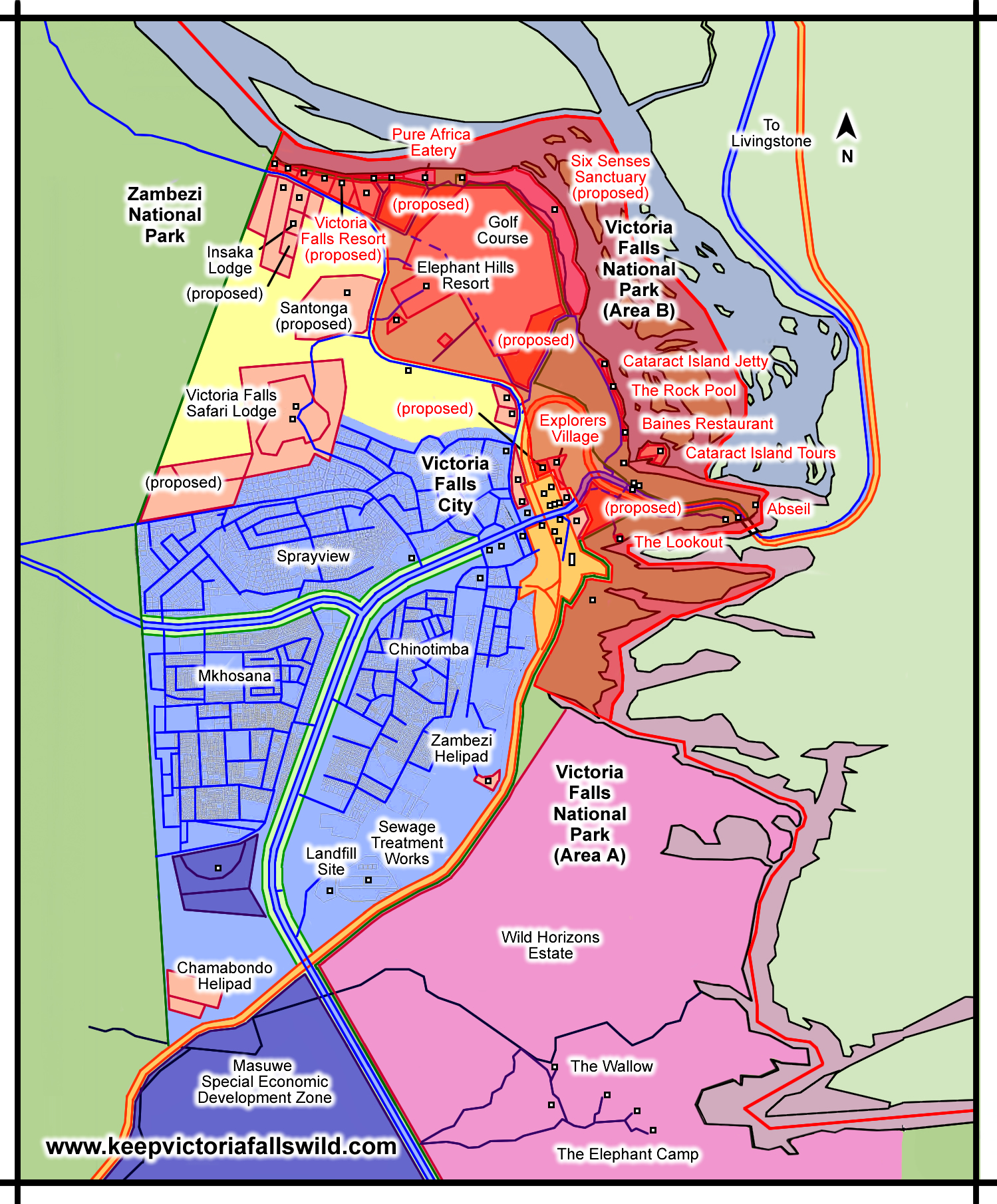
Recent developments at the Victoria Falls during 2011-2025, showing Open Land Areas
(shaded in red, numbered) designated as permanently protected under the 1975
Outline Plan. New and proposed developments within this area since 2011 in red.
[click image for larger view].
It should be noted that the Committee’s original request specifically included reference tourism developments within the Zimbabwean area of the WHS HESZ - the Baines Restaurant and launch of tours to Cataract Island (and for which an ESIA had already been explicitly requested by the Committee (World Heritage Committee, 2017)).
“Requests the States Parties to provide information on all developments proposed in the Property, its Buffer Zone, and wider setting, including on a permit for two commercial tourism development sites within the Zimbabwean component of the property recognised as highly sensitive zones according to the previous J.I.M.P.” (World Heritage Committee, 2024)
The State Parties have yet again chosen to ignore this request and decline the opportunity to present details of these developments, despite the fact that tours to Cataract Island have been promoted since April 2022 and the Baines Restaurant opened in July 2023.
A legal challenge against the Baines development, raised by a group of concerned residents in mid-2022 when construction had just begun on the site, remains unheard and unresolved three years later, with Zimbabwe National Park Authority maintaining the development is within the MESZ which allows such developments. We have repeatedly shown that the location of the development is, and always has been, within the HESZ (KVFW, 2023, 2024, 2025).
Under the heading of 'Proposed Activities and Developments within the Buffer' the report also states
"There are currently no accepted proposed activities within the World Heritage Site." (State Parties, 2025a, p.16)
This statement is notable for the fact that it does not say that there have been no proposed developments within the Buffer Zone - it merely repeats the previous claim that there are no new proposals within the WHS itself. This appears therefore to be yet another attempt to deliberately deceive and mislead the Committee.
Recent developments within the Buffer Zone surrounding the WHS include the construction of the new Zambezi Helipad overlooking the gorges downstream of the Falls and development of the Big Tree Curio Market area, together with the proposed Victoria Falls Resort riverside development, the mysterious Stand 1815 development (land sold by Council for development in 2024, development not identified in Council Master Plan) and the significant Masuwe Development Zone proposal (all on the south bank). There are also concerns over several tourism development sites identified in the 2024 Victoria Falls City Council Master Plan (Victoria Falls City Council, 2024) and identified under the 1975 Outline Plan as ‘restricted permanently’ from all new development (Rhodesia Ministry of Local Government and Housing, 1975)
Mosi-oa-Tunya Resort Mitigations
Despite stating their commitment to implementing the recommendations of the 2022 Reactive Monitoring Mission Report (World Heritage Centre, 2023) the State Party of Zambia appears to indicate that there will be no further action to address planning infringements, and mitigation measures requested in the RMM Report, relating to the controversial Mosi-oa-Tunya Resort development (operating as the Radisson Blu Mosi-oa-Tunya Resort) while also claiming that the development has no impact on the Site’s OUV.
“The State Party of Zambia wishes to formally clarify that the development in question - although partly State-owned - proceeded without fully meeting all the approval conditions set out in the ZEMA Decision Letter. This situation arose from differing interpretations of key terms relating to building characteristics, specifically height limits and setback requirements from the riverbank.
Notwithstanding these challenges, the State Party confirms that the Outstanding Universal Value (OUV) of the MoT/VF WHS has not been adversely affected. None of the attributes that directly convey the OUV have been physically or visually compromised. In particular, the development does not impact the waterfall, gorges, islands, or any of the geological formations and geomorphological processes that constitute the core values of the property.
Furthermore, the natural beauty and aesthetic qualities of the Site remain intact. The construction materials, colours and architectural design were selected to harmonise with the surrounding environment. All structures remain within the prescribed tree-height limits, thereby preserving the natural skyline and ensuring visual integration with the landscape.
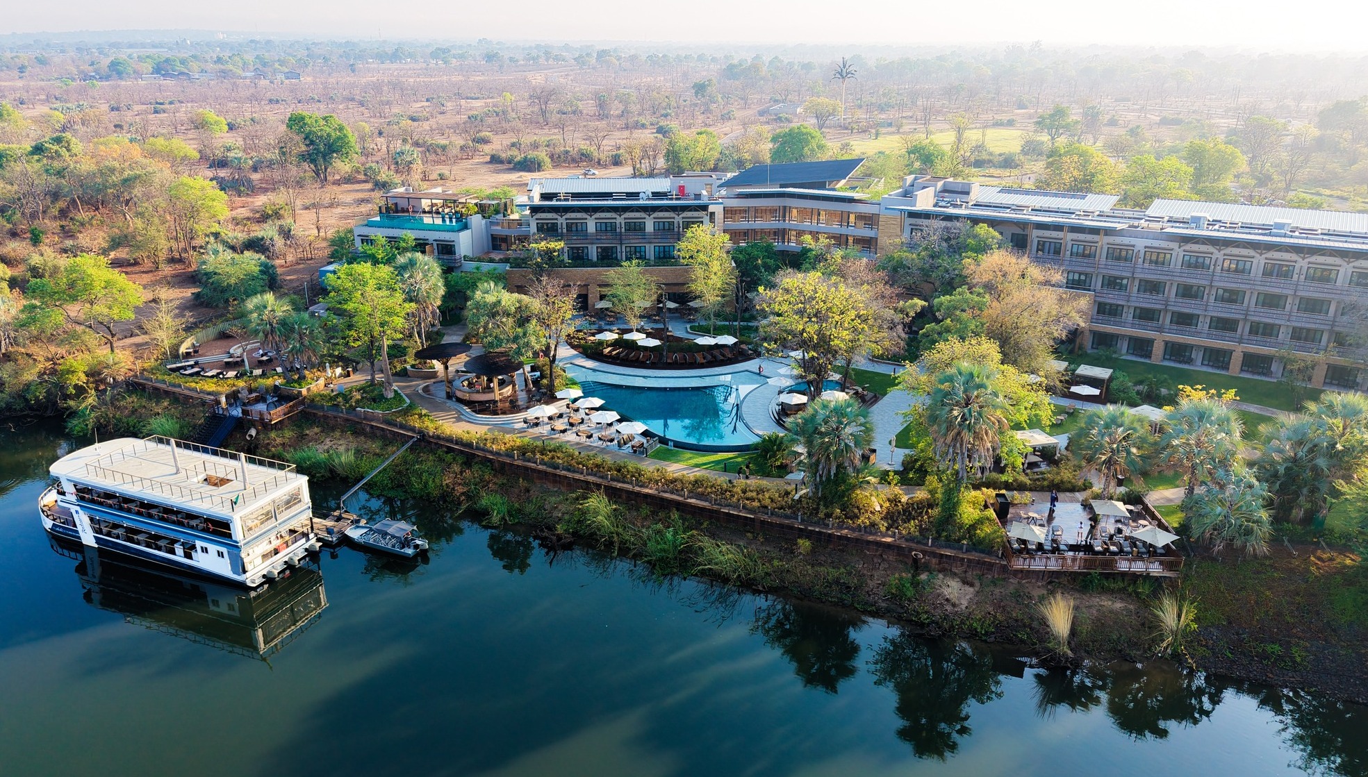
Radisson Blu Mosi-oa-Tunya Resort Development (2025)
[click for larger view]
The State Party also affirms that dismantling or reversing components of the project would pose greater environmental and socio-economic risks. The resulting disturbance, combined with the loss of significant economic benefits, would undermine the environmental, social and economic pillars of sustainable development.
To ensure strengthened compliance going forward, the National Heritage Conservation Commission has written to ZEMA requesting that all future developments within the World Heritage Site adhere strictly to the World Heritage Convention’s Operational Guidelines and applicable national legislation.
The State Party further acknowledges the limited and inconsistencies in the 2007 Zonation Scheme and its associated permissible-use thresholds, which in some cases proved unrealistic and contributed to interpretation difficulties. The State Party is therefore undertaking a review to ensure that the revised zoning framework is clear, practical, and fully aligned with the protection of the Site’s Outstanding Universal Value.” (State Parties, 2025a, p.8)
The statement identifies ‘differing interpretations’ in definitions of height limits and setback requirements from the riverbank, without defining or clarifying the exact restrictions which are supposedly in place or actions to ensure that these definitions are universally applied.
The State Parties position therefore also ignores the decision of the Committee recorded at its 2023 session, which repeated the recommendations of the RMM Report:
“Regrets that the construction of the Mosi-oa-Tunya Livingstone Resort Hotel has concluded despite the Committee’s request to halt further activities and urgently requests;
- the State Party of Zambia to implement mitigatory measures integral to legal conditions of approval issued by Zambian Environmental Management Authority and contained in the Joint Management Plan (JIMP),
- the ESIA has been revised in accordance with the Guidance and Toolkit for Impact Assessments in a World Heritage Context
- and a comprehensive Environmental and Social Management Plan has been developed and submitted together with impact assessments to the World Heritage Centre;.” (World Heritage Committee, 2023)
In short the State Parties are choosing to ignore the direct mitigation measures relating to this development and specifically requested by the World Heritage Committee in the RMM Report and repeated in their 2023 decision. This is after construction of the development started without disclosure to UNESCO and continued despite the Committee's request to abandon the proposal (World Heritage Committee, 2019).
New Joint Plan Finalised?
The report confirmed the finalisation of the new JIMP document, originally due for submission by end of June 2024, extended to June 2025 at the Committee's 46th Conference (World Heritage Committee, 2024):
“The Joint Integrated Management Plan (JIMP) has been finalised, ensuring the inclusion of robust safeguards, clearly defined thresholds, and appropriate zonation measures to mitigate developmental pressures and safeguard the property’s Outstanding Universal Value (OUV). The precise boundaries of the property and its buffer zone have been clearly delineated to facilitate the conclusion of the Retrospective Inventory, and the harmonization of national and transboundary plans and policy documents has been successfully achieved to ensure a cohesive management framework.” (State Parties, 2025a, p.5)
A later statement indicates that the new plan was finalised and submitted in June 2025.
"The State Parties of Zambia and Zimbabwe jointly validated and submitted the updated Joint Integrated Management Plan (JIMP) for the Mosi-oa-Tunya/Victoria Falls World Heritage Property on 30th June 2025 for review, as part of ongoing efforts to strengthen the coordinated management framework and ensure the sustained protection of the property's OUV." (State Parties, 2025a, p.13)
A timetable for the development of the Plan, published as an Appendix, appears to clearly indicate that the Plan was finalised and submitted in December 2025.
Boundary Modification Requested
The Report indicates that a boundary modification request has been formally submitted.
“The States Parties of Zambia and Zimbabwe take note of the Committee’s decision and are pleased to confirm that the request for the boundary modification of the Mosi-oa-Tunya /Victoria Falls WHS has been formally submitted in accordance with UNESCO guidelines and procedures. This submission reflects the joint commitment of both States Parties to ensure that the property’s boundaries are clearly defined and appropriately aligned to enhance the protection of its Outstanding Universal Value (OUV) and to strengthen the overall management and conservation framework of the site.” (State Parties, 2025a, p.9)
Modified Management Zones
The report noted that the new General Management Plan for the Mosi-oa-Tunya National Park was yet to be finalised, hinting at changes in the ‘zonation terminology’ to align consistently across all documents.
“Zambia wishes to note that the General Management Plan (GMP) for the Mosi-oa-Tunya National Park is currently being updated. Both State Parties agreed that the finalisation of the Joint Integrated Management Plan (JIMP) should draw upon the revised National Park Management Plans to ensure that the primary focus remains the protection of the OUV of the World Heritage Property, rather than generic park-level ecological management.
“Accordingly, it was necessary to harmonise the zonation terminology (Figure 1) and the limits of permissible use between the key Zambian institutions - the National Heritage Conservation Commission (NHCC) and the Department of National Parks and Wildlife (DNPW).” (State Parties, 2025a, p.10)
Yet another map of the WHS is presented alongside this statement (State Parties, 2025a, Figure 1, p,11). The map shows revised management zones for the the WHS reflecting existing tourism utilisation rather than conservation value. The map indicates the creation of two new management zone definitions, a 'Nature Conservation Zone' (Green) and 'Sustainable Development Zone' (Yellow) for the main area of the Falls. The changes appear to redesignate significant areas on both sides of the Falls currently protected under the HESZ designation to the 'Sustainable Development Zone.' The Falls and upstream section of the river appears to remain protected within the HESZ or equivalent, although it is not clearly indicated as such (the choice of tonal colours to indicate different zones is unclear and difficult to interpret).
When the State Parties presented the 2016 JIMP they committed to only introducting changes tothe zones which improve the conservation protections for the WHS (State Parties, 2016).
“Modifications to these zones have been made in line with the 1989 World Heritage Bureau recommendations as well as the prevailing inconsistent historic land use. Future modifications can only be made if only they contribute to the enhancement of the OUV.” (State Parties, 2016, p.26)
The changes proposed in this map appear to indicate a significant dilution and reduction in protections over significant areas in the immediate vicinity of the Falls.
It should also be noted that the map shows the incorrect boundaries (indicated by the green lines) of the Zambezi and Victoria Falls National Parks and corresponding Council-controlled area. (The boundary of the southern downstream section of the WHS is correctly shown and is also the correct boundary of the VFNP).

The 2025 State of Conservation Report Zonation Map
(State Parties, 2025a, Fig.1, p.11) [click image for larger view].
Without any supporting text descriptions, definitions or details of the presented zonation amendments, either in the State of Conservation Report or Joint Integrated Management Plan, it is impossible to assess the potential implications or impacts of the revised management zone proposals presented in this map. The map must therefore be clearly rejected by the Committee until represented in a context that allows full interpretation and review by the Committee and to avoid future potential confusion - as in the case of incorrect maps presented in earlier JIMPs (Keep Victoria Falls Wild, 2024; 2025).
The review of the WHS management zonation has been in progress for several years.
“On 16th April 2024 the State Parties transmitted to the World Heritage Centre, an interim report on the progress of review of the JIMP, also highlighting their progress on the review of the zonation of the property.” (World Heritage Centre, 2024)
2025-2030 Joint Integrated Management Plan
Despite statements within the State of Conservation Report that the new JIMP document was finalised and submitted in June 2025, the version submitted to UNESCO is clearly labelled ‘draft’ and dated December 2025. The document is not signed by the respective representatives of the State Party managing authorities.
The Plan represents background details on the geology, geography and ecology of the Site, incorporating many new details and maps from other recent reports, including the 2024 Zambezi/Victoria Falls National Park Management Plan, together with a detailed management action plan.
Revised Boundary Description
The document presents a revised text description of the WHS. This is not the existing agreed boundary and presumably reflects the formal boundary modification request, which is yet to be approved, although without any supporting details on the changes, their justifications or their implications.
“Zambia: Starting [at a point at the upstream extreme of the WHS] in the Zambezi River on the international boundary (E25.75; S17.89) the core zone boundary follows the Mosi-oa-Tunya National Park directly north to where it crosses the Zambezi River riverine (Approx. 300m from the banks of the Zambezi River [E25.75; S17.84]); then it follows the riverine of the Zambezi River [downstream] up to Gate 4 Camp, thence along the floodplain contour to a point adjacent to the Bushtracks jetty, thence [continuing downstream] along the River Drive Road to its intersection with Sichango Drive, thence north-eastwards along Sichango drive (150 m) and then south eastwards maintaining a distance of 400 m from the high-water mark of the Zambezi River a point before the main park entrance gate at the junction of the River Drive Road with Nyasa Road, the boundary then briefly follows the River Drive Road south eastwards, then for 1.43 km along the Zambezi River riverine (400 m from the high-water mark [and including the site of the Mosi-oa-Tunya Resort]) to the Maramba River. Then following the Maramba River upstream to the Mosi-oa-Tunya park boundary (E 25.86; S -17.88). Then following the Mosi-oa-Tunya park boundary in a southerly direction to the Songwe River (but excluding the addition to the park known as the “horn”). Then down the Songwe River (the park boundary) to the Zambezi River [and International boundary]. Thence following the international boundary upstream to the starting point.
Zimbabwe: Starting at the most easterly point of the Victoria Falls NP which is in the Zambezi River (E25.91; S17.98; Rapid 16) the core zone boundary follows the boundary of the Victoria Falls NP in a westerly direction, then a northerly and easterly direction following in part the railway line and a series of beacons (both City and NP – see Annex) to the Zambezi NP. Thence following the “river road” in the Zambezi NP up to picnic site 10 (E 25.75; S -17.85). Thence a straight line northwards to the international boundary. Thence following the international boundary to the starting point at Rapid 16, the starting point.” (State Parties, 2025b, p.6)
The description for the Zambian side of the boundary appears to now include the area along the Zambezi River where the controversial Mosi-oa-Tunya Resort development was constructed over 2019-22. This conflicts with the map presented in the State of Conservation Report (State Parties, 2025a, Fig,1, p.11), which shows the boundary as following the line of the riverbank down to the Maramba River confluence. (Note the map is also incorrect in showing proposed boundary amendments to the extreme upstream and downstream boundaries on the north bank, rather than the existing agreed boundary, and including the area known as the ‘horn’ as within the WHS boundary - which is not and never has been within the area of the WHS).
The area upstream of the Maramba River confluence was previously argued as being within the MTNP but outside the WHS boundary, so allowing the controversial construction of the Resort. It appears odd that only now that the conservation value of this area has been completely compromised that the State Party should seek to include it within the protection of the WHS. The justification and implications for including this area within the WHS need to be assessed and reviewed.
The description of the boundary for the southern, Zimbabwean, side of the river appears to describe the existing agreed border (and is supplemented by Map in Annex 2 showing boundary beacons (State Parties, 2025b, Annex 2, p.64)).
The boundary description presented in this JIMP should be the current, existing boundary, with a summary of the formally requested boundary modifications, highlighting changes, justifications and implications.
It is unclear why a wider margin of the north-bank upstream riverine fringe is not included within the WHS. The area is already protected within the MTNP and considering its acknowledged ecological vulnerability and the recognised threat of tourism development is appears a notable omission from the original inscription listing.
The Plan also presents a revised total area for the WHS of 8,209 ha, including 4,261 ha in Zambia and 3,948 ha in Zimbabwe (State Parties, 2025b, p.7), rather than the 6,860 ha recognised at inscription, with 3779 ha in Zambia and 3,081 in Zimbabwe. Again there is no supporting explanation or interpretation of the change in figure, which must reflect more significant adjustment (1,349 ha) than the proposed boundary amendments indicate and needs further explanation.
We believe this revision to be due to the exclusion of the area of the river itself from the figures presented at inscription, but without explanation it is impossible to tell if the figures represent an adjustment of the existing agreed or proposed revised area.
Buffer Zone Issues
The State Parties appear determined to interpret the concept of the Buffer Zone as the wider protected areas of the Mosi-oa-Tunya and Zambezi National Parks, the area originally proposed for the WHS and rejected by the World Heritage Committee in favour of concentrating on the core area of the Falls and river corridor immediate upstream and downstream the Falls.
The inclusion of this wider areas of the Mosi-oa-Tunya and Zambezi National Parks as the Buffer Zone distracts and dilutes reporting focus from the core area of the WHS and must again be categorically rejected by the World Heritage Committee.
The whole point of the Buffer Zone is that it surrounds the boundary of the Site and acts as a buffer between areas protected under the WHS designation and external areas bordering WHS (and preventing ‘hard border’ edge effects). It is therefore of particular significance where the boundary borders land which is not already protected. The Buffer Zone should be reinstated as a 500m zone surrounding the entire WHS, and especially the areas where this boundary borders land not protected under National Park status, as originally presented in the 2007 JIMP (State Parties, 2007).
Missing Management Zones
Regarding the management zonation of the WHS, under the Executive Summary it is recorded:
“Zone summary - The three tiered zonal system (Red, Yellow, Green) is based on the most protection for the central part of the resource where developments and activities are controlled (Red Zone), followed by the outer zones (Yellow, Green) with looser restrictions, hence allowing more facilities away from the important red zone of the core area. The zone system reflects the original zoning approved in 2007 and moves away from the 2016 zone system that saw key riverine areas and the rainforest in Zimbabwe becoming yellow zones. The current red zone provides protection for the waterfall, the upstream riverine areas and islands and the downstream gorges as far as the Nsongwe River (to match the designation on both sides of the river).” (State Parties, 2025b, p.iv)
A further note details:
"Zonation: This section outlines the rationale and criteria used for zoning the WHP and explains the basic management guidelines to be employed in each zone. The WHP is subdivided into three zones namely (i) High ecologically sensitive (ii) Medium ecologically sensitive (iii) Low ecologically sensitive. Modifications may be made only if they enhance the protection of the OUV of the site." (State Parties, 2025b, p.3)
A further reference to the management zonation is made the 'Management Background' section, referring to the Mosi-oa-Tunya National Park (Zambia):
"The [Mosi-oa-Tunya National] park is divided into three zones which align to the zones defined for the WHP. The park map, and its zones are shown as Annex 1 [3].
- Natural Protection Zone = Red Zone
- Semi-Wilderness Zone = Green Zone
- Conservation Limited Use Zone = Yellow Zone (most of the area north of the Maramba River)" (State Parties, 2025b, p.22)
And the Zambezi and Victoria Falls National Parks (Zimbabwe):
"The Victoria Falls National Park has five zones which align to the WHP zone system. The red zone includes part of the gorges, the rain forest and the upper river. The Zambezi National Park has four zones, one of which includes the riverine strip of the WHP Red Zone. The park map, and its zones are shown as Annex 1:” (State Parties, 2025b, p.23)
The corresponding section on zonation within the Plan is mysteriously a blank page, the page numbering of the document indicating that four pages (from pages 29-32) are blank or missing from the document. Reference to the contents pages indicates three maps which are missing (Figure 14: WHP showing Core and Buffer Areas; Figure 15: World Heritage Property Core Area Zones’ and Figure 16: WHP Red Zone) and four missing tables (Table 7: WHP – Purpose of the Core Zones; Table 8: WHP Core Area Zones; Table 9: Core Zones of the WHP; and Table 10: Existing developments in the red zone, 2023).
It is fairly evident therefore that the content of these pages have been intentionally removed from the document before its submission to UNESCO. The State Parties appear to be intentionally hiding from the World Heritage Committee the revised text description and supporting information relating to the management zonation which is currently being proposed for the Site in an attempt to divert and delay the World Heritage Committee from commenting on these proposals.
It is perhaps notable that the map presented in the 2024 Zambezi/Victoria Falls National Park Management Plan is not reproduced within the new JIMP document, despite statements indicating the harmonisation of these plans, management zones and terminology.
The Appendices do, however, present two maps detailing the management zonation within the National Parks on either side of the river. The map for the north-bank MTNP, presumably from the forthcoming GMP, shows existing tourism concessions within the NP and WHS, identified as ‘Sustainable Development’ areas, including Thorntree Lodge, Sussi & Chuma Lodge, David Livingstone Safari Lodge, Radisson Blu Mosi-oa-Tunya Resort and Royal Livingstone and Avani tourism developments, the United Air Charters stand (under private land title) and the significant extent of the ZESCO area surrounding the immediate area surrounding the Falls. Also indicated is a ‘Special Use Zone’ around the Maramba river and extending significantly into the area of the WHS.
Without any supporting text descriptions, definitions or details it is impossible to assess the potential implications or impacts of this revised management zone proposal.

MoTNP Zonation Map (State Parties, 2025b, Annex3, p.65) [click image for larger view].
The map of the south-bank Zambezi and Victoria Falls National Park management zones appears to show the existing ‘three-tier’ zonation previously presented in the 2024 Zambezi/Victoria Falls National Park Management Plan (Zimbabwe Parks and Wildlife Management Authority, October 2023).

Zambezi/Victoria Falls National Park Zonation Map (State Parties, 2025b, Annex3, p.66) [click image for larger view].
The lack of detail on the zones comes after a specific request for the bounaries, zonation and buffer zone to be reviewed in the new document, building on the agreed zonation under the current (2016) JIMP.
“Further requests the State Parties to submit a request for a boundary modification in accordance with the Operational Guidelines to set the precise boundaries of the property and its Buffer Zone, aligned with past Committee Decisions and the property’s Statement of OUV and including details of the internal zonation system and its rationale to protect the property and its OUV" (World Heritage Committee, 2023)
Reaction and Recommendations
There is a growing list of issues and concerns with the management of the Victoria Falls World Heritage Site (Keep Victoria Falls Wild, 2023; 2024; 2025). Rather than bringing clarity on these issues, the State of Conservation Report and Joint Integrated Management Plan submitted to the World Heritage Centre does not acknowledge or address any of these concerns, and if anything cause yet further confusion.
We have already highlighted the issues and problems with the management zone map presented in the State of Conservation Report (State Parties, 2025a, Fig.1, p.11). This map must be specifically rejected by the World Heritage Centre.
While the State of Conservation Report emphasises the State Parties continued commitment to the World Heritage process, the presentation of these incomplete, inconsistent and in some places inaccurate reports and map implies a disrespect and disregard for the World Heritage Committee and the UNESCO World Heritage Listing. The State Parties have repeatedly proved unwilling to disclose controversial developments within the WHS until after they have been agreed, and in some cases after they have been constructed. In the case of the Baines Restaurant the State Party of Zimbabwe still refuse to disclose details of the development.
The State Parties should therefore be requested to resubmit a corrected and updated State of Conservation Report to specifically include disclosure of all tourism developments and all alienated land under third-party influence within the boundaries of the WHS and the surrounding 500m Buffer Zone. This disclosure should include the exact locations and area of all concessions or alienated land and include historical developments such as the ZESCO development area on the north bank, transport and infrastructure corridors and all tourism developments, both existing and proposed within the WHS and surrounding Buffer Zone. Unless and until there is full disclosure of all developments within the WHS the State Parties commitment to the World Heritage process should be seriously questioned.
Despite being referred to as a finalised document, the new Joint Plan presented to UNESCO is clearly labelled as a Draft document and more significantly is missing pages and content relating to the crucial issue of management zonation within the World Heritage Site. This is viewed as yet another attempt by the State Parties to delay and distract the World Heritage Committee in the hope of avoiding clarification of the management zonation for the Site and implications for recent tourism developments which have been constructed, and others which are still proposed, within the south-bank section of the World Heritage Site.
The World Heritage Centre should therefore also reject the ‘Draft’ Joint plan and the State Parties should be requested to immediately submit the full and final JIMP document, including details on the existing and proposed management zonation, with justification and analysis of implications and impacts on the Site’s OUV, so that the proposals can be reviewed by the Committee at its July 2026 Conference (the document has already been extensively delayed from its original requested submission date of mid-2024). Failure to address this issue ahead of the July Conference will merely add to the growing list of problems relating to the Site.
The State Parties should also be reminded that provision of annual visitor information for the Site is key to the monitoring of tourism utilisation and that they have yet to provide figures for 2023 and 2024.
References
Links to external sites or pdf downloads, open in a new window.
Keep Victoria Falls Wild (2023) State of Development Report 2023.
Keep Victoria Falls Wild (2024) State of Development Report 2024.
Keep Victoria Falls Wild (2025) Special Report on the Riverine Fringe.
Rhodesia Ministry of Local Government and Housing (1975) Victoria Falls Outline Plan, Written Statement. Victoria Falls Planning Scheme Area. Ministry of Local Government and Housing. Department of Physical Planning.
Roberts, P. (2026) Paradise Lost? Conservation and Development of the Victoria Falls (1900-2025). First Edition, February 2026. Zambezi Book Company / CreateSpace Independent Publishing.
State Parties (2007) 2007-2012 Victoria Falls/Mosi-oa-Tunya Joint Integrated Management Plan (external download, opens in a new window).
State Parties (2016) 2016 Victoria Falls/Mosi-oa-Tunya State of Conservation Report and 2016-2021 Victoria Falls/Mosi-oa-Tunya Joint Integrated Management Plan (external download, opens in a new window).
State Parties (2025a) 2025 Victoria Falls/Mosi-oa-Tunya State of Conservation Report (pdf download [18.9 mb], opens in a new window).
State Parties (2025b) Draft 2025-2030 Victoria Falls/Mosi-oa-Tunya Joint Integrated Management Plan (pdf download, 18.9 mb).
UNESCO (2023) Conservation Issues, Analysis and Conclusions.
Victoria Falls Bits and Blogs (18th January 2026) Zambia and Zimbabwe Present Incomplete Joint Management Plan for Victoria Falls World Heritage Site.
Victoria Falls Bits and Blogs (27th January 2026) Zimbabwe Fail to Disclose Illegitimate Developments within Victoria Falls World Heritage Site to UNESCO.
Victoria Falls City Council (2024) Victoria Falls Master Plan Documents. Draft Report of Study (April 2024); Draft Written Statement (July 2024); Main Map (Preferred Option); Supporting Map (insert section) (November 2024).
World Heritage Centre (2023) Joint Mission Report Mosi-oa-Tunya, Victoria Falls (Zambia/Zimbabwe) 9-13 February 2022 (pdf download, 3.16 mb)
World Heritage Centre (2024) Conservation Issues, Analysis and Conclusions.
World Heritage Committee (2017) Decisions Adopted, 41COM 7B.22
World Heritage Committee (2019) Decisions Adopted, 43COM 7B.34.
World Heritage Committee (2024) Decisions Adopted, 46COM 7B.60.
Zimbabwe Parks and Wildlife Management Authority (October 2023) Zambezi/Victoria Falls National Park General Management Plan (2024-2034). October 2023 (approved April 2024). (pdf download [8mb], opens in a new window)