Keep Victoria Falls Wild
Conservation and Development of the Victoria Falls
The 2024 Victoria Falls City Council Master Plan
The Three Options
Preferred Option (November 2024)
Missing Developments
New Development Areas
The Mysterious Stand 1815
Threat to World Heritage Site Status
Wildlife Movement Corridors
People-Wildlife Conflict
Carrying Capacity Concerns
Map Updated (March 2025)
Corruption Claims
The following text has been adapted (with permission) from
researched and written by Peter Roberts and published in February 2026
The 2024 Council Master Plan
In mid-2024 Victoria Falls City Council undertook stakeholder consultations towards the development of a new Master Plan for the Council-controlled area, to replace the 1975 Outline Plan (VFCC, August 2024). The meetings were held prior to the public exhibition of the Victoria Falls Master Plan Draft Report of Study (VFCC, April 2024) and supporting Written Statement (VFCC, June 2024) in October (VFCC, October 2024). The documents were published online in November together with two detailed maps (Preferred Option VF/MP/01, undated, and Supporting Map VF/MP/02, also undated) (VFCC, November 2024a; b). A revised version of the preferred option, dated March 2025, was subsequently released (VFCC, March 2025).
In media reports Victoria Falls town planner, Ms Ntombizami Ncube, stated
“Our masterplan is now a public exhibition. We have already advertised two issues and we are waiting for the third issue... The masterplan will be on public exhibition for the next two months and we request all stakeholders to visit the Victoria Falls Town Planning offices or our website, all the documents are there for viewing. Issues that came out was the need to balance conservation of nature and development planning needs. We would want to expand, we don’t want to encroach into any restricted zones, especially the World Heritage Site, we are not touching.” (Victoria Falls Bits and Blogs, 6th November 2024)
The new plan will replace the 1975 Outline Plan which has guided the development of the resort town for nearly fifty years and successfully, for the most part, guided the development of the town and protected the open areas extending towards the river and Falls.
The Draft Report summarised the 1975 Victoria Falls Outline Plan, repeating the details presented in the 2001 Victoria Falls Combination Plan and acknowledging the protected status of areas designated Open Space:
“Areas designated as public and private ‘open space’ in the vicinity of the Falls and the Zambezi River are restricted permanently against building development, with the exception of buildings which are essential for the administration of these areas.” (Victoria Falls City Council, April 2024)
Under key findings relating to environment and tourism the supporting Written Statement (VFCC, June 2024) acknowledged the threat of tourism developments within the riverine fringe and emphasised the importance of, and a commitment to, protecting the riverine corridor:
"Demand for tourism sites in riverine environments threatens their biodiversity and aesthetic appeal.” (VFCC, June 2024, p.11)
"Wildlife corridors will be clearly defined, maintained, and respected... The WHP and RAMSAR sites need to be respected to maintain the aesthetic value of the key attraction, the waterfall and surrounds...
"Maintenance of the natural beauty and an ecologically sound environment is critical to a healthy tourism economy. The riverine forest and wildlife corridors need to be protected against development and integrated into the City as they are an important part of the unique character of the City.” (VFCC, June 2024, p.14)
"Ensure the conservation and protection of woodlands, riverine areas, scenic areas, and the Falls itself.” (VFCC, July 2024, p.19)
The Statement summarised the key findings and recommendations from the Draft Report of Study and presented three maps representing low (‘Controlled Expansion Option’), medium (‘Preferred Option’) and high (‘Dangerous Wildlife Containment Option’) development scenarios (VFCC, June 2024). Apart from the brief notes supporting each map and a summary table of ‘pros’ and ‘cons’ (VFCC, June 2024, p.22) there is no detailed analysis of these options or their implications.
Both the medium and high development options include expansion of the Council-controlled area south of the Kazungula Road westwards and involve the alienation of significant areas of the Zambezi National Park (12 km² and 18 km² respectively).
The Three Options
The low or ‘Controlled Expansion’ development option, aims ‘to maintain the conservation and aesthetic values of the Falls while improving tourism.’ It is the only option which prevents all further development in the northern part of the Council-controlled area stretching towards the river and recognises and maintains the ‘permanently protected’ areas identified within the 1975 Outline Plan, protecting established wildlife corridors and refuge areas. Future growth is limited to the existing Council developed area and the new development area south of the Masuwe River (along the main Bulawayo road transport corridor).

Map showing Council controlled area, Victoria Falls City Council Master Plan, Option 1
(From Victoria Falls Master Plan (VFCC, June 2024, p.23))
[click image for larger view].
The medium or ‘Preferred’ development option aims ‘to improve tourism while allowing controlled expansion of the city.’ The option involves the alienation of 12 km² of the Zambezi National Park and expansion of the City westwards along the Kazungula Road transport corridor, with tourism on the northern side of the road corridor and predominantly residential southwards to the Chamabondo River. The option identifies a 70 metre road reserve (either side, from central line of road).
The map appears to indicate the resurrection of the Santonga development in the northern part of the Council controlled area (not shown in the low development option) and development of remaining riverside stands upstream of Elephant Hills Resort (leaving a significantly reduced wildlife access corridor), together with the development of various other areas originally identified as ‘permanently protected’ under the 1975 Victoria Falls Outline Plan.

Map showing Council controlled area, Victoria Falls City Council Master Plan, Option 2
(From Victoria Falls Master Plan (VFCC, June 2024, p.23))
[click image for larger view].
The high or ‘Dangerous Wildlife Containment’ development option aims ‘to maximize tourism growth centred on the waterfall,’ although the main element of this option is to exclude dangerous wildlife (primarily elephant and buffalo) from the City areas through fencing. The option involves the alienation of approximately 18 km² of the Zambezi National Park, including a section of the WHS riverine fringe and the expansion of the tourism development zone extending upstream from the Elephant Hills Resort into the new expanded Council controlled area. This option again shows the expansion of the City westwards along the Kazungula Road transport corridor and identifies a 70 metre road reserve.

Map showing Council controlled area, Victoria Falls City Council Master Plan, Option 3
(From Victoria Falls Master Plan (VFCC, June 2024, p.23))
[click image for larger view].
Preferred Option (November 2024)
In October 2024 the Council announced the draft Victoria Falls Master Plan had been adopted (confusingly referring to the plan as being ‘draft’ while also indicating that the document had been official adopted).
“The Victoria Falls City Council, hereby gives notice, in terms of subsection (2) of section 15 of the Regional, Town and Country Planning Act, Chapter 29: 12, as read with section 8 of the Regional, Town and Country Planning (Master and Local Plans) Regulations (RGN 248 of 1977), that the Draft Victoria Falls Master Plan has been Adopted and is now on public exhibition commencing 17th October 2024 and ending 16th December 2024.” (Victoria Falls City Council, October 2024)
The Draft Plan and supporting documents and maps were made available to download online on the Council’s website in November. Included were detailed maps of the ‘preferred option’ (Victoria Falls City Council, November 2024a, b). In addition to the alienation of 12 km² of land protected under the Zambezi National Park for development the map includes the whole of the VFNP within the expanded Council-controlled area (Victoria Falls Bits and Blogs, 23rd December 2024). National Parks have yet to make any public comment on the Plan or maps and the plan offers no land trade-off for the loss of the previously protected area of the Zambezi National Park.
The Draft Plan proposes to significantly expand the area controlled under the Council from just 22 km² to over 244 km², including significant expansion south from the area identified for the Masuwe development south of the Masuwe River to the airport,’ including the Nakavango Estate and Fuller Forest areas.

Map showing proposed expansion of Victoria Falls City Council controlled area, annotated to highlight current area under Council control (outlined in white), area proposed to be annexed from Zambezi National Park (red) and Masuwe Development Zone (purple). Click image for larger (un-annotated) jpg version - 5.37mb (VF/MP/01, VFCC, November 2024a). The map clearly shows the Victoria Falls National Park as within proposed new Council Controlled area.

Map showing proposed enlarged section of central Victoria Falls City Council controlled area. (VF/MP/02, VFCC, November 2024b)
[click image for larger jpg version - 1.15mb].
Missing Developments
The three option maps (VFCC, June 2024) and the final ‘preferred option’ map (VFCC, November 2024) all omit showing the Inyathi Lodge development and adjoining Horse Safaris camp along Park Way (established in the late 1990s/early 2000s). It is thought that this is perhaps a mapping oversight, although it raises concerns over the planning and stakeholder process for such an ommission to have gone unnoticed.

Northern part of the Council-controlled area showing Inyathi Lodge and Victoria Falls Horse Safaris, omitted from Council Master Plan Maps.
(Adapted from Victoria Falls City Council Master Plan, 2024) [click for larger view]
New Development Areas
While the Draft Report acknowledged the area of permanently protected ‘Open Space’ stretching to the River and the Victoria Falls, the detailed map of the ‘preferred option’ shows several significant new development areas within this protected zone. The map indicates further riverside developments (between A’Zambezi and Palm River Lodges, and between Palm River and Elephant Hills) together with a new development area covering a significant area of land between the south-eastern boundary of the Elephant Hills Golf Course and Zambezi Drive road running down to the river and past the Big Tree, with the line of the road also being the boundary of the VFNP and WHS. The area has also recently seen the establishment of the Big Tree Curio Market.
The area between Zambezi Drive and the Elephant Hills Golf Course is of local ecological significance, being dominated by Acacia and supporting a variety of different bird and other species associated with this ecotone and which are not found within the wider area. It is therefore of significant local conservation importance. The area is included within the ‘Open Space’ designation under the 1975 Outline Plan (and identified as Area 7 in the 2001 Combination Plan) which identified the area ‘restricted permanently’ from development, as well as being within the WHS 500 m Buffer Zone.
The Master Plan maps also show an expanded development areas within the Railway Loop, again 'restricted permanently' under the 1975 Outline Plan (and identified as Area 12 in the 2001 Combination Plan), and within the Road Loop on the approach to the Victoria Falls. This area, stretching from below the now closed Kingdom Hotel down to the Rainforest visitor car park, was again identified under the 1975 Outline Plan as 'restricted permanently' from development (and identified as Area 14 in the 2001 Combination Plan). As the area adjoins the Victoria Falls National Park and World Heritage Site (HESZ) along its south-eastern edge the entire area falls within the 500m Buffer Zone which surrounds the World Heritage Site.
The map also shows the long-proposed Santonga project, located to the north of the Victoria Falls Safari Lodge Estate (on land identified as ‘Rural’ under the 1975 Outline Plan).

Northern part of the Victoria Falls Council-controlled area showing new tourism development areas including the Santonga development, Stand 1815 and proposed new tourism development areas between golf course and Zambezi Drive Road (Area 7), railway loop (Area 12) and road loop (Area 14). Adapted from Victoria Falls City Council Master Plan, April 2024) [click for larger view]
The Mysterious Stand 1815
Not included in the Master Plan maps is the mysterious Stand 1815, a 1.6 hectare stand located in the region of the Council water intake point and north-western corner of the Elephant Hills Golf Course, first offered for sale by Council in January 2024 and again in February 2025 following procedural irregularities. The Calls for Expression of Interest indicated permission for a lodge/hotel development, yet there is no corresponding tourism development area shown in the Master Plan maps. A stand in this area would no doubt border the VFNP and World Heritage Site, and fall within the 500m Buffer Zone.
Threat to World Heritage Site Status
The Plan Draft Report highlighted development encroachment into the World Heritage Site and possible resulting loss of the Site’s status.
“The entire Victoria Falls National Park and parts of the Zambezi National Park form the core area of the UNESCO World Heritage Property. The property is zoned and the area close to gorges and along the Zambezi River is zoned as being highly ecologically sensitive and therefore has restrictions on the amount and type of development. This area has been encroached by a number of developments, thereby eroding its value as a World Heritage Property. In extreme circumstances the property could find itself on the list of endangered World Heritage Properties or even be delisted, something that could affect tourism, and hence the future of the City.” (VFCC, April 2024, p.197)
Wildlife Movement Corridors
The Victoria Falls City Council Master Plan Draft Report of Study (VFCC, April 2024) identified the protection of wildlife movement corridors and management of human-wildlife conflict as among the key issues to be addressed by the Plan.
“The City is constrained by high-value parks and wildlife conservation estate on all sides leaving little space for expansion. Within the City, there is pressure to keep wildlife corridors open which also is a development constraint.
“The City is currently open to wildlife, which is part of its attraction as a tourist destination, but this results in human wildlife conflict. Wildlife corridors need to be recognized and enforced and human wildlife-conflict managed.” (VFCC, April 2024, p.v)
The Report gives interesting insights into local wildlife movements and behaviour wildlife corridors, noting season movements of elephant into the area and also crossing the river into Zambia.
“Wildlife movements are dictated by changes in the availability of water and food. During the rains the herds break up into smaller groups and disperse throughout the area. In the dry season, the animals congregate into larger herds and become much more dependent on water sources. The Zambezi and Masuwe Rivers, the springs in Zambezi Park, and the pumped pans in Chamabonda and Kalisosa Vleis are vital water-points in the dry season. The seasonal movement of wildlife, especially elephant, covers extensive distances. Towards the end of the dry season, some of the animals move into Zimbabwe from areas in the north east of Botswana. They return to Botswana when the rains begin... Elephants also wade across from Zimbabwe to the islands in the Zambezi River and on to the Zambian mainland.” (VFCC, April 2024, p.64)
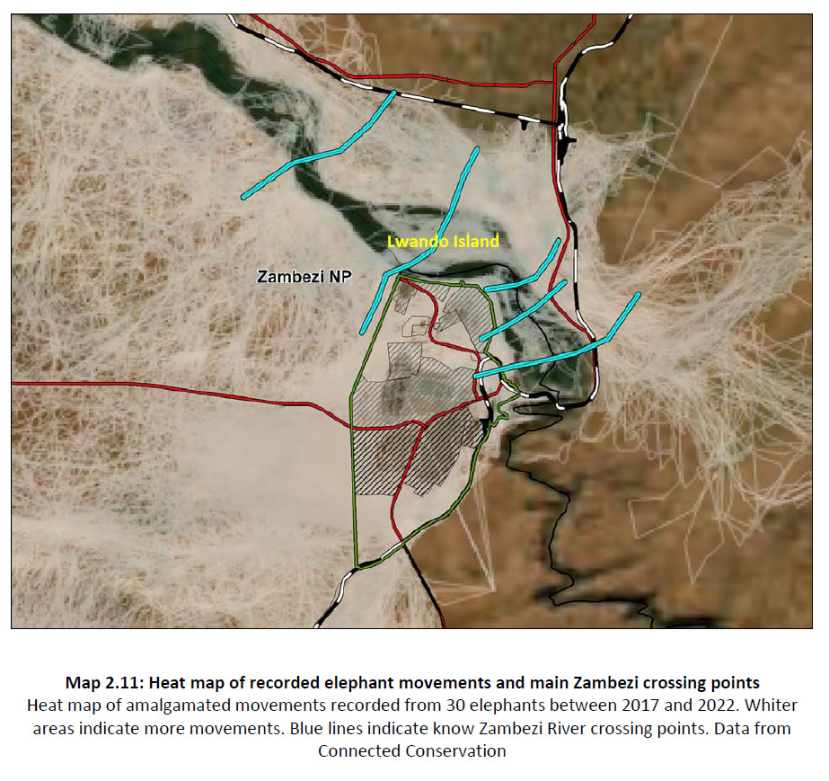
Map showing elephant movement across Zambezi River and main crossing points
(from Victoria Falls City Council Master Plan Draft Report of Study, May 2024) [click for larger view]
Additional daily patterns in wildlife movement to the river were also recorded, the Report noting a lack of clarity in the identification of wildlife movement corridors with tourism and urban development restricting and impacting on movement.
“There is also daily movement of the larger mammalian species (mainly elephant and buffalo) during the dry season. They spend the day feeding inland and then move near the Zambezi River during the night...
“The main watering points for wildlife in the Victoria Falls town area are along the Zambezi River banks upstream from the Falls and two areas of artificial wetland below Ilala Lodge and near the railway line. In recent years extensive developments along the river banks have reduced the access to water and the riverine habitat available to wildlife. Despite recognising the importance of wildlife as a tourist attraction the ‘wildlife corridors’ have not been demarcated clearly and wildlife movements are becoming more and more restricted by development in the town... Boat cruises and jetties along the riverbank are added barriers to the wildlife movements.” (VFCC, April 2024, p.64)
The increasing development and fragmentation of core habitat areas and movement corridors has displaced animals and increased people-wildlife conflict.
"Disturbance of traditional migration routes has resulted in animals moving into unsuitable or marginal areas and changing their drinking and feeding habits, which leads to an increase in stress and the likelihood of animal-human conflict.” (VFCC, 2024, p.64)
The importance of the riverine fringe and open areas allowing movement to the river was illustrated in reference to local elephant movement data maps.
"The importance of the remaining riverine fringe to elephants is displayed in Map 2.9. Two different interpretations of the data are shown to elephant movements through the northern part of the city. Data was collected from 30 elephants over a six year period [2017-2022]. Dots show actual recorded positions while the ‘heat map’ shows an analysis of the time spent at those points. Clearly some areas (Zambezi Riverine, under the ZPWMA, and the two artificial wetlands (outflow from water pumping station and below main hotels etc.)) are refuge areas and different to transit corridors where they move relatively quickly between refuge areas and water.” (VFCC, April 2024, p.64)
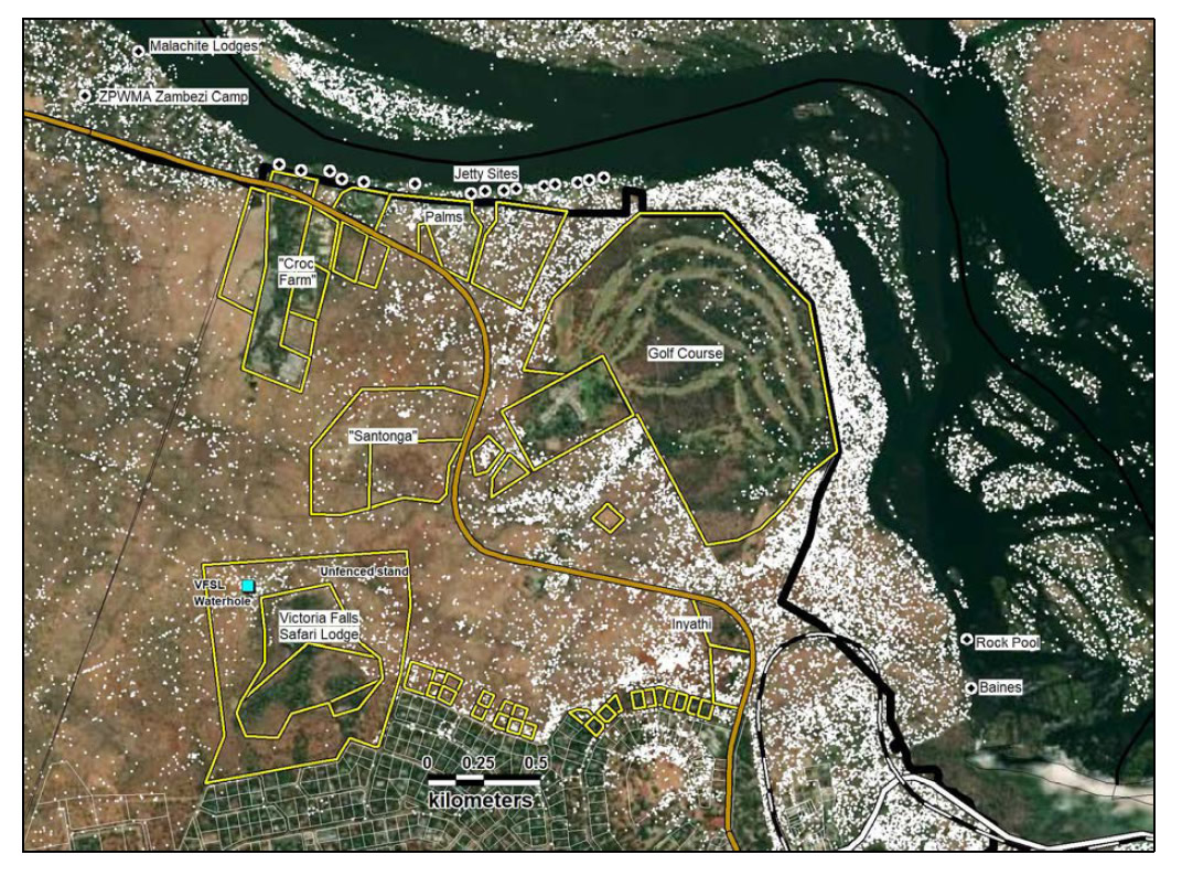
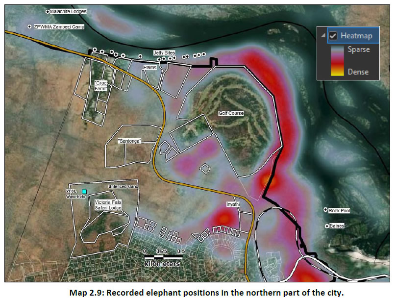
'Map 2.9' - Two maps showing elephant movement patterns around Victoria Falls
and showing importance of riverine fringe surrounding golf course
as an elephant refuge area (from Victoria Falls Master Plan
Draft Report of Study VFCC, May 2024) [click for larger view]
While noting the importance of refuge areas, and their difference to movement corridors, this is the only mention to their significance.
The Report identifies three main elephant movement corridors through the Council-controlled area:
“Although elephants can be found throughout the City there are three key corridors and these need to remain open if maintaining large herbivores in the City is a desired future.
1 - Golf Course/Zambezi Riverine. This is a vital link that is in danger of being closed. At the northern end stand allocations (but not yet developed) leave a gap of 100m for elephant transit.
2 - Big Tree. Again this is a vital but threatened link to the Zambezi River for elephants coming from the Zambezi NP past the Victoria Falls Safari Lodge. New developments in the World Heritage riverine areas are further restricting river access.
3 - Landfill. This is a well-used link between the Zambezi NP and the railway line (Victoria Falls NP boundary). The landfill site and sewage ponds themselves are an attraction but movement is often up to the Rainforest and the Golf Course.” (VFCC, April 2024, p.67)
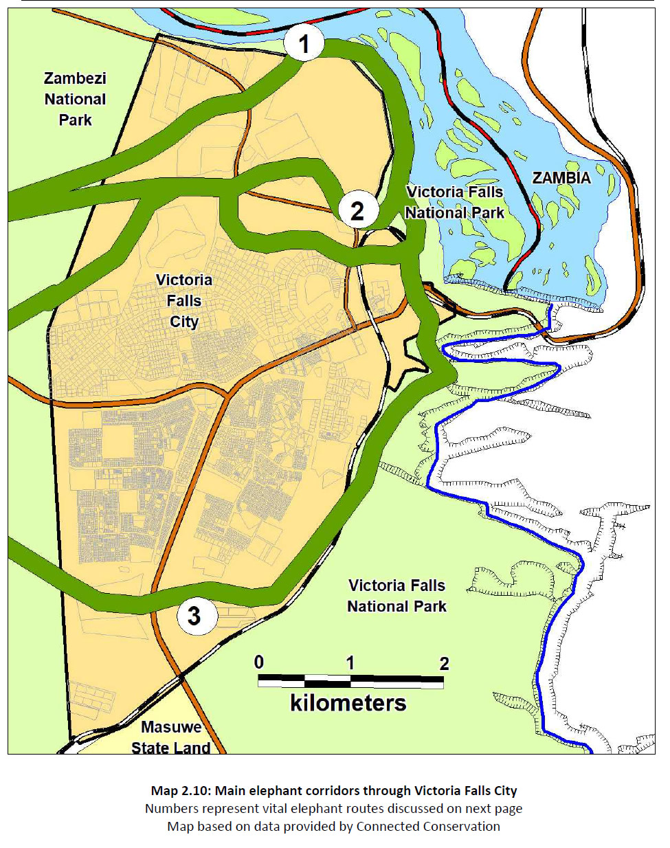
Map showing main elephant movement corridors through the Victoria Falls City Council-controlled areas (from VFCC, April 2024) [click for larger view]
People-Wildlife Conflict
The Report further clarified in several additional statements that development pressures were directly impacting on wildlife movement with implications for human-wildlife conflict and emphasised the need to recognise and respect wildlife corridors in reducing people-wildlife conflict.
“Tourism and residential developments are affecting wildlife corridors and dispersal areas and this has a knock-on effect with human-wildlife conflict.” (VFCC, April 2024, p.155)
“As restrictions of wildlife movement increase the potential for human-wildlife conflict increases significantly.” (VFCC, April 2024, p.91)
“Need for Management of Wildlife and Human conflict - the Master Plan must recognise and accommodate wildlife corridors.” (VFCC, April 2024, p.204)
Regarding people-wildlife conflict the Plan identified a lack of information collation prevented further analysis.
“Little data was available on the incidence of wildlife-human conflict and it is recommended data on the number and details of animal problem incidents and their causes are collected regularly so that patterns can be established and appropriate measures taken to mitigate the conflicts. The incidence of crop raiding by elephants in communal areas has decreased in recent years as the elephant movements become more restricted by fencing, the airport expansion and habitat clearance for villages and agricultural lands.” (VFCC, April 2024, p.197-8)
The Council's plans to develop further riverside tourism stands (such as the Victoria Falls Resort proposal), together with Stand 1815, the Big Tree Area, Railway Loop and Road Loop, combined with National Park plans to develop the Elephant Hills riverine fringe for tourism under the Six Senses 'tree lodge' proposal appear to be in direct conflict with these warnings and recommendations. Development of these areas can be predicted to lead to significant displacement of local elephants from traditional refuge areas and movement corridors, with a corresponding increase in people-wildlife conflict on both sides of the river the most likely consequence.
Read more on People-Wildlife conflict issues - Paying the Price.
Carrying Capacity Concerns
The 2024 Draft Victoria Falls Master Plan estimates the current tourist accommodation capacity of the south bank at between 5,000 and 6,000 beds (Victoria Falls City Council, 2024), with hotel and other developments already announced (such as the Victoria Falls Resort development) expected to easily bring this total to over 6,000 within the next year or two (while the centrally located Kingdom Hotel, with nearly 300 rooms, still lies empty).
The published documents present no forecasts or modelling estimates of the projected growth in tourism capacity (most notably in terms of accommodation/beds) presented under the three development options and which will see increasing peak-season tourist visitor pressures at the Victoria Falls World Heritage Site.
The National Park General Management Plan, however, highlighted the growing pressures of increasing visitor numbers. (See National Park General Management Plan Carrying Capacity Concerns for more.)
Map Updated (March 2025)
A revised version of the detailed ‘preferred option’ map was prepared in March 2025 and subsequently published online (VFCC, March 2025). The revised map shows additional tourism development zones to the south of the Masuwe SEZ area, as well as including two existing tourism development stands on the norhern edge of the urban area, the Inyathi Lodge development and neighbouring Horse Safaris camp along Park Way, both omitted from earlier maps./p>
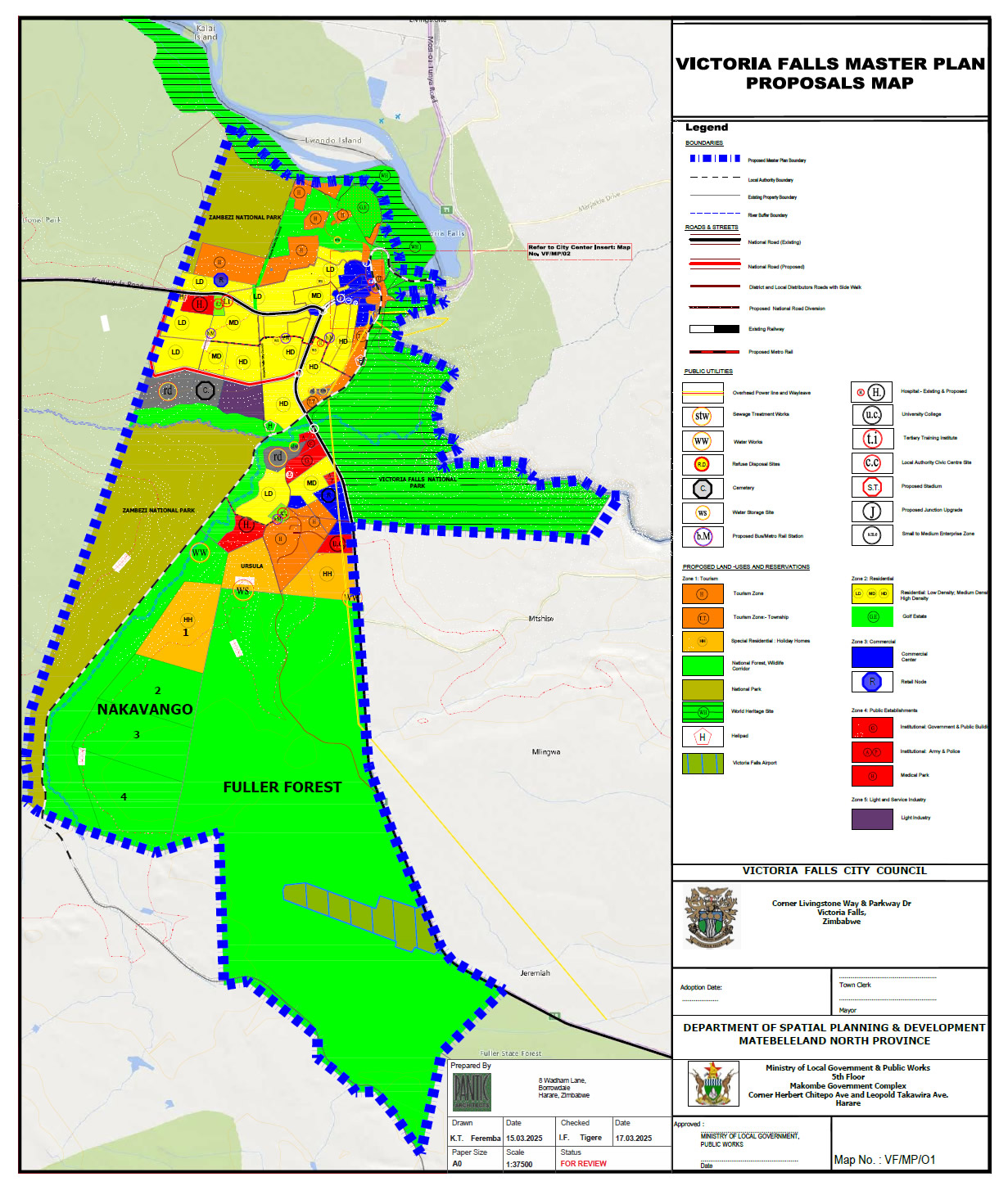
Amended version of the Master Plan 'preferred option' map (March 2025)
Corruption Claims
In December 2024 the Victoria Falls Town Clerk, Mr Ronnie Dube, was suspended by the Council on claims of abuse of office and large scale corruption involving the illegal allocation of residential stands for development (Victoria Falls Bits and Blogs, 4th December 2024; 5th December 2024).
"The Zimbabwe Anti-Corruption Commission (ZACC) has uncovered a massive corruption scandal involving high-ranking officials at Victoria Falls City Council, including Mayor Tuso Moyo and Town Clerk Ronnie Dube. The investigation, which reveals illegal land deals and fraudulent tenders, has sent shockwaves through the city. The investigation, disclosed in a ZACC report dated November 4, 2024, suggests that both Moyo and Dube, along with several senior council employees, were engaged in a scheme to illegally allocate land for personal and political gain.” (Victoria Falls Bits and Blogs, 4th December 2024)
Among widespread allogations of corruption the Zimbabwe Anti-Corruption Commission report identified the Victoria Falls City Mayor, Mr Prince Thuso Moyo, as a shareholder in the Baines Restaurant (ZACC, 2024).
Within a few days the Minister of Local Government and Public Works, Daniel Garwe, ordered the reinstatement of Mr Dube, referencing some vague procedural irregularities in the Council’s original resolution on the suspension (Victoria Falls Bits and Blogs, 8th December 2024).
Mr Dube has been Town Clerk since 2017 with his tenure due to end in February 2025, although despite regulations limiting heads of local authorities to a maximum of two four-year terms media reports in mid-2024 indicated Mr Dube had somehow secured an extension to his contract beyond this period (Victoria Falls Bits and Blogs, 15th June 2024). One of Mr Dube’s main responsibilities in office has been overseeing the development of the new Council Master Plan, casting doubt over the integrity of the process.
A media report from March 2025 detailing the irregularities allegedly committed by Mr Dube named ex-National Park Director General, and current Director General of the Central Intelligence Organisation (CIO), Dr Fulton Mangwanya, as one of those benefiting from the unprocedural allocation of residential stands.
“A Board of Inquiry was established on December 4th, 2024 by the Mayor to investigate the claims, which found ‘criminal acts were committed’ by the town clerk. Among other irregularities, the board found 12 stands were set aside under instructions by the town clerk.
“‘The Vetting Committee was later given names to allocate the same stands to. They did say that two of the stands were then allocated to Portia Sarutsozo, an alleged girlfriend of Ronnie Dube and Priscilla Thabolo, Ronnie Dube’s former wife. The applicants who had indicated interest but did not qualify but were still allocated stands included Moreblessing Tomu (Dube’s wife),’ read part of the inquiry report. Other beneficiaries allegedly included Dr Fulton Upenyu Mangwanya, who became Director General of the Central Intelligence Organisation (CIO) this year, Jenfan Muswere, the Information Minister, and former MP, Temba Mliswa.
“After the town clerk was suspended, the minister intervened, instructing the council to reinstate Dube. Garwe defended his decision, arguing the mayor and councillors had failed to follow due process in suspending Dube.” (Victoria Falls Bits and Blogs, 6th March 2025)
The Minister further clarified that the Zimbabwe Anti-Corruption Commission (ZACC) had been called to widen its investigation into the Council.
“The minister revealed the Zimbabwe Anti-Corruption Commission (ZACC) had been invited to investigate the Victoria Falls council as a whole, rather than focusing solely on Dube.
“'After the town clerk was reinstated, we invited ZACC to come to Victoria Falls and investigate Victoria Falls as a council, not only an individual. It’s now a work in progress. Once that is done, decisions to be made thereafter will be informed by the legitimate report from ZACC, not the report that was being floated on social media,’ Garwe said.” (Victoria Falls Bits and Blogs, 6th March 2025)
In August the Victoria Falls Residents Consortium petitioned police to speed up a corruption probe into the Town Clerk.
“Allegations against Dube date back to 2024, when a board of inquiry ruled that he had a case to answer over the disposal of council property. Issues flagged included the allocation of residential stands under the BE100 scheme, the hiring of a consultancy said to have prejudiced council of over US$157 000, and the sale of Stand Number 1829...
“In its latest correspondence to national police spokesperson Assistant Commissioner Paul Nyathi, the residents’ consortium demanded updates on case number 6219269, filed against Dube.
“On behalf of Victoria Falls community, Herbert Ncube and Trymore Ndolo, under the Victoria Falls Residents Consortium banner, filed a case against Ronnie Dube, the Town Clerk of Victoria Falls City Council. We made numerous follow ups per attached correspondence, and the residents feel the responses from the authorities do not satisfy their expectations in line with the evidence at hand,” reads part of the letter.”
In June they were told the case had been referred back to the Zimbabwe Anti-Corruption Commission.
“‘Kindly be advised that the case was initially reported to and investigated by the Zimbabwe Anti-Corruption Commission. The outcome was not shared with the police. In light of this, we recognise that the police cannot conduct parallel investigations with ZACC,’ local police said in their June 20th correspondence.
"The consortium, however, insists the delays have worsened public concerns, citing what they describe as ‘fresh allegations of abuse of land allocation procedures at the VFCC (Victoria Falls City Council) and harassment of employees for cooperating with ZACC and the board of inquiry... Despite all attempts to arrest corruption at VFCC, the cancer seems to be gathering momentum,’ the consortium warned.” (Victoria Falls Bits and Blogs, 23rd August 2025)
In October it was reported that Council were repossessing stands allocated to residents within the BE100 area in order to re-allocate to "new potential beneficiaries and is compelling them to pay a 'facilitation fee' to increase their chances of acquiring the stands.” (Victoria Falls Bits and Blogs, 23rd August 2025)
Next: The 2025-2030 Victoria Falls Joint Plan
References
Links to external sites or pdf downloads, open in a new window.
Roberts, P. (2026) Paradise Lost? Conservation and Development of the Victoria Falls (1900-2025). First Edition, February 2026. Zambezi Book Company / CreateSpace Independent Publishing.
Victoria Falls Bits and Blogs (15th June 2024) Pushback as Victoria Falls council boss clings to power.
Victoria Falls Bits and Blogs (6th November 2024) Victoria Falls masterplan open to scrutiny.
Victoria Falls Bits and Blogs (4th December 2024) Multi-million-dollar scandal rocks Victoria Falls council.
Victoria Falls Bits and Blogs (5th December 2024) Corruption and abuse of office - Victoria Falls Town Clerk and 2024 CEO of the year suspended.
Victoria Falls Bits and Blogs (8th December 2024) Government reverses 'unprocedural suspension' of Victoria Falls Town Clerk Ronnie Dube.
Victoria Falls Bits and Blogs (23rd December 2024) Victoria Falls City Council development 'masterplan' aims to annex conservation areas for development.
Victoria Falls Bits and Blogs (6th March 2025) Minister defends Vic Falls Town Clerk, accuses residents’ groups of politics.
Victoria Falls Bits and Blogs (23rd August 2025) Vic Falls residents push for clarity in Town Clerk corruption probe.
Victoria Falls City Council (April 2024) Victoria Falls City Master Plan. Draft Report of Study. April 2024. (pdf download [34.3 mb], opens in a new window).
Victoria Falls City Council (June 2024) Victoria Falls City Master Plan. Written Statement. June 2024. (pdf download, opens in a new window).
Victoria Falls City Council (November 2024) Main Map (Preferred Option VF/MP/01, undated) and Supporting Map VF/MP/02 (undated) (insert section)
Victoria Falls City Council (March 2025) Main Map (Preferred Option), Revised. (VF/MP/01, March 2025)
Zimbabwe Anti-Corruption Commission (2024) Corruption Report: Victoria Falls City Council. November 2024.