Keep Victoria Falls Wild
The Victoria Falls - A Natural Wonder
Conservation Context
Conservation Context
Ecology/Biological Features
Conservation Context
The 2021-2030 Strategic Environmental and Social Impact Assessment Report (SESIA) for the Mosi-oa-Tunya/Victoria Falls World Heritage Site, covering an area extending over a 30 km radius from the Falls (the 'Plan Area', presented a detailed introduction to the ecological and conservation aspects of the Victoria Falls area.
The Victoria Falls are located at 17o56’ South and 25o 55’ East. They are on the Zambezi River along the border between Zambia and Zimbabwe in the districts of Livingstone in Southern Provinces of Zambia and in Hwange District of Matabeleland North of Zimbabwe. The Study area is having a radius of 30km on each side of the Victoria Falls encompassing an Area of 2800Km2. It ranges from downstream of the Katombora rapids in the west to the fourteenth (14) gorge in the south of the Zambezi River. The Area includes Livingstone City, part of Kazungula District and Victoria Falls town; as well as three national Parks namely – Mosi-Oa-Tunya National Park, Zambezi National Park and the Victoria Falls National Park. It also includes traditional land in Zambia of Chief Mukuni, Musokotwane and Sekute and the communal lands of Hwange Rural District. There is also significant forest land on both sides.
The area surrounding the Victoria Falls is classified as tropical dry or deciduous forest and woodland in the afro-tropical realm. The predominant woodland type is kalahari woodland, which grows on the overlying Kalahari sands. The Zambezi River runs through the middle of the area and creates its own special riverine biome which is distinct from the general biome classification. Upstream, this forms a wide, shallow river valley with riverine forest and many islands. At the Victoria Falls itself the Zambezi River has cut the underlying basalt rock to form a series of gorges over 100 meters deep from the main level of the land. The river becomes narrow and confined within the steep cliffs. The narrow rocky banks, feeder streams and gorges also have a distinctive habitat." (State Parties 2021, p.21-2)
Conservation Status
"The Victoria Falls are of unique geology, geomorphological and aesthetic value. They are one of the most spectacular waterfalls in the world with a curtain of falling water 1708m wide and 108m deep. The zig-zig course of the gorge downstream, caused by successive erosion through the weakest faults in the basalt, enable viewers to see the Falls for their complete length from the opposite bank at a distance of less than 100m. The surrounding national parks contain flora and fauna representative of the area but by no means unique. The woodland types surrounding the area are very characteristic, but the riverine forest above the Falls is unique, especially the area kept moist by the spray from the Falls, also known as the “rain forest”. It is for this reason that in 1989 UNESCO, at the request of the governments of Zambia and Zimbabwe, declared the Victoria Falls, upstream river, its banks and islands and the downstream gorges as a World Heritage Site. It was considered to be still in a natural condition only partially affected by man. It met the natural criterion (iii) now criterion (vii) for the “status of the World Heritage Sites of superlative natural features” and criterion (iv) now criterion (viii) of being an important habitat for rare or endangered species (IUCN, 1989; Goriup and Harvey, 1997).
"The area enclosed by the World Heritage Site falls within the boundaries of the three national parks: Zambezi National Park, Victoria Falls National Park in Zimbabwe and Mosi-Oa-Tunya National Park in Zambia. It is therefore entirely in public ownership and protected under the Zambia National Heritage Conservation Commission Act No. 173 of 1989 and the Zimbabwe Parks and Wildlife Act (Chapter 20:14) of 1975.
"The three National Parks cover a wider area than the World Heritage Site and the legal protection in these areas is the same. This prohibits any permanent development but allows access with minimum management interventions. Hunting, cutting of trees, stone cropping or removal of dead wood is strictly prohibited. On both the Zambian and Zimbabwean sides there are forest areas managed for the indigenous hardwood cropping – usually through timber concessions led by the forest department and forest commission respectively. In Zimbabwe some hunting and photographic safaris are also permitted in these forestry areas." (State Parties 2021, p.21-2)
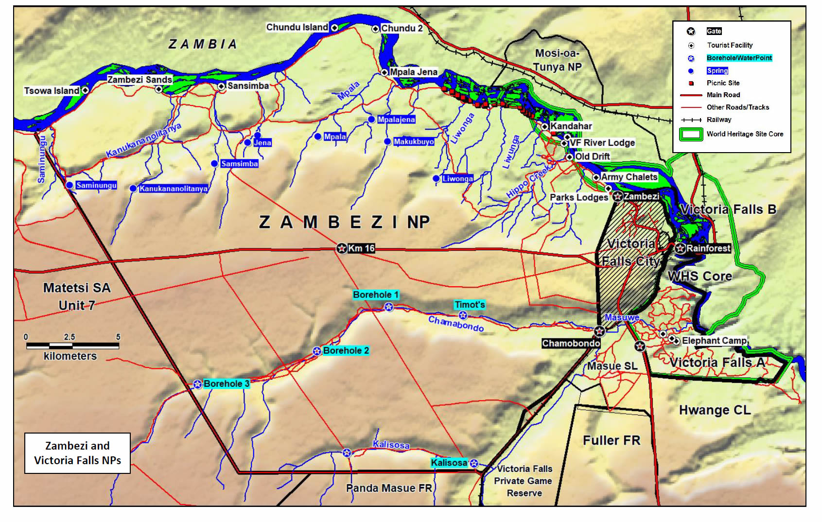
Map showing Victoria Falls and Zambezi National Parks
(from 2024 Victoria Falls/Zambezi National Park Management Plan, p.ix)
[click image for larger view].
Ecology/Biological Features
The 2021 SESIA report noted six predominant eco-zones within the wider area of the Falls.
"The whole study area lies in agro-ecological regions I in Zambia, IV and V in Zimbabwe, which are characterized by low fertility soils (e.g., Kalahari Sands). Rainfall is between 450-650 mm and with periodic seasonal drought and severe dry spells in the rainy season. Agricultural production is limited to livestock production and drought resistant crops; nevertheless, some maize is produced in the area, despite its unsuitability. This natural region is also suitable for game ranching. The predominant habitat is woodland making about 90% of the area. On the Zimbabwean side, the protected area network which forms the natural wildlife habitat is made up of the Zambezi National Park (56,010 ha); Victoria Falls National Park (Victoria Falls A, 1,904 ha and B, 436 ha). The forest areas within the 30km radius are managed by the Zimbabwe Forestry Commission. The Forestry Commission manages about 58,900 ha of the Mvutu, Fuller and Panda Masue Forest estates. Communal Land makes the bulk of the area. There is also Private Land around Victoria Falls City and protected areas.
"There are two main vegetation zones in the vicinity of the Victoria Falls/Mosi-Oa-Tunya World Heritage Site: the riverine forest close to the river and the semi-deciduous open woodland further away. A closer analysis of these woodlands reveals six main vegetation types based on biological features (Zambia-Zimbabwe JSMC, 2016) namely:
(i) Riparian Forest;
(ii) Kalahari Woodland;
(iii) Mopane;
(iv) Mixed Scrub Vegetation;
(v) Mukusi Woodland; and
(vi) Miombo woodlands.
The riverine vegetation community, and its extension, the rainforest, have a high diversity of plant species considering its size, with more than 800 species having been recorded. The variety of the plant species adds to the great aesthetic value of the site, and the trees along the river are important for river bank stability. An important feature of the vegetation of the rainforest is the large number of herbaceous and climbing plant species. The rainforest also contains some species of restricted distribution or outlying populations although they have not been categorised as ‘threatened’, but provides an important habitat. Further from the river, vegetation species composition is mostly determined by edaphic factors, with the deep Kalahari Sand vegetation dominated by teak (Baikiaea plurijuga), while the shallow basalt soils are predominantly Mopane (Colophospermum mopane) woodlands, with the rest of the tree species shown in Appendix 6.1a. Vlei/grassland systems e.g. Chamabonda vlei, associated with soils of low drainage are an important component of the vegetation in the area. Species composition of the vleis varies with the moisture regime. Dominant species include Digitaria milinjiana, Heteropogon contortus and thatching grasses...
Forest lands are managed by the respective forest departments in each country. On the Zimbabwean side the main objectives of the establishment of the forest were to (i) produce exploitable timber of the main commercial species on a sustained yield basis; (ii) increase productivity through multiple land use practices including utilization of minor forest products; (iii) increase the soil and water conservation value of the forests; and (iv) develop the amenity value of the forests. Selective and concentrated on three commercial species, Baikiaea plurijuga (Zambezi teak), Pterocarpus angolensis (blood wood/mukwa/kiaat), and Guibourtia coleosperma (mchibi) for railway sleepers, furniture and flooring. Currently there is no timber harvesting for commercial purposes in the forest area within the 30km radius. The management of forest areas has been faced by a number of resource challenges. In both Zambia and Zimbabwe, there is significant illegal cutting for fuel wood, illegal charcoal production and selective poaching of curio wood trees, particularly at the edges of the forest areas, and is a management challenge.
Utilization of trees in the forest is significant, with 74% of all stems with signs of utilization being from five commercially valuable species, and 63.5% from one; Baikiaea plurijuga. Exploitation of woodland for fuelwood, charcoal, timber and curio wood has been particularly heavy near forest areas, communal/trust lands and towns. In some areas the canopy cover has been reduced to less than 35%. Mopane Woodland is a good fodder species for browsing animals; its attraction for elephants has meant that in some areas where elephants have concentrated and there are no tourism developments, the Mopane Woodland has been reduced to coppiced bushes, e.g., parts of the Zambezi National Park.
The Riparian Forest is found along the Zambezi River and its inland tributary banks and on the islands. It is important for river bank stability, as a habitat for much of the biodiversity in the area and as a landscape feature. A special section of riparian forest is the “rainforest” overlooking the Falls which is maintained by the spray. The rainforest is vulnerable to reduction in the spray particularly in drought years and to invasion by exotic species such as Lantana camara.” (State Parties 2021, p.74-75)
The 2016 Joint Integrated Management Plan for the World Heritage Site expanded:
“The predominant natural habitat in the Victoria Falls/Mosi-oa-Tunya World Heritage Site is woodland (Meynell et al., 1996). Shalwindi (2000) states that according to LANDSAT imagery and the 1:500,000 vegetation map of Zambia, four main vegetation types are observed in the WHS namely; Mopane, Mixed scrubland, Riparian and Swamp vegetation types. A closer analysis of these woodlands reveals six main vegetation types (Meynell et al., 1996) namely Riparian Forest, Kalahari woodland, (iii) Mopane, (iv) Mixed Scrub Vegetation, (v) Mukusi Woodland and (vi) Miombo Woodlands. The vegetation in the WHS is divided into six types based on biological features as described below:” (State Parties, 2016b)
a) Riparian Forest: The Zambezi River, in common with all rivers in tropical Africa, has a distinct fringing vegetation of gallery or riparian woodland. The Riverine Forest is found along the banks of the Zambezi, Songwe and Maramba Rivers and on some islands. On the riverbanks it is with a width rarely more than 20-100m wide from the high water mark (Fanshawe, 1975, Meynell et al., 1996). At its best development, riparian forest is a three storeyed forest with a closed evergreen canopy attaining 21m in height. Some common tree species that occur here are Diospyros mespiliformis, Trichilia emetica, Syzyguim guineense ssp barotsense, Syzyguim cordatum, Mimusops zeyheri, Hyphaene coriacea, Hyphaene petersiana and Pheonix reclinata. Also common are Phragmites mauritianus and Cyperus papyrus.
This habitat houses the highest concentration of animals and is the most sought and threatened by human developments. A small section of the riverine woodland is the ‘Rainforest’ found opposite the Victoria Falls. Species such as Rotala cataractea seem to favour the highly specialized conditions prevailing in the ‘Rainforest’. Overally, the rainforest contains a highly specialized forest flora of an island character. Species such as Sebea pentandra, Loberlia kirkii, and Gladiolus unguiculatus are rare herbaceous species with very specialized habitat requirements. Another species of interest is the rare fern Cheilanthes farinose.
The central deep sandy ridges of some of the islands produce a non-riparian vegetation, with affinities to Kalahari woodland. Dichrostachys cinerea, Acacia polyacantha and Terminalia sericea are also to be found in these areas.
b) Kalahari Woodland: This woodland type mainly occurs on Kalahari sands (Meynell et al., 1996). The term Kalahari woodland therefore embraces all woodlands on Kalahari sand with the exception of the vegetation derived from the destruction of dry evergreen forest (Fanshawe, 1969). The Kalahari sands are deep and well-drained and are characterized by Baikiae plurijuga, Guibortia coleospermum and Schinziophyton rauteneii. This woodland type is of great economic importance because of its utilization in terms of the curio curving industry, furniture manufacture, firewood supply and ethnomedicology (Meynell et al., 1996). B. plurijuga produces a valuable timber commercially exploited in both Zambia and Zimbabwe for railway sleepers, mining timbers and parquet flooring (Fanshawe, 1975, Meynell et al., 1996). This woodland type is independent of the Zambezi. Other species of interest in this woodland are Burkea africana, Erythrophleum africanum, and the Uapaca spp.
c) Mopane Woodland: This one storeyed open woodland with a deciduous canopy of 6-18m high (Fanshawe, 1969, Chidumayo et al, 2004) is the second largest habitat in the Victoria Falls World Heritage Property on the Zambian side. It is found between the Riverine Forest and Mixed Scrubland. The dominant mopane is pure or almost pure (Fanshawe, 1969), thus frequently forming a near monoculture over considerable areas (Chidumayo et al, 2004). Scattered elements of Munga woodland occur in places mainly represented by Acacia nigrescens, Adansonia digitata, Combretum imberbe, Kirkia acuminata and Lannea sthulmannii. Mopane woodland thrives well in alkaline sandy soils. The physiognomy of Mopane woodland on the alluvial flats is largely conditioned by the depth and duration of flooding during the rainy season. The most abundant tree that occurs in this area is Colophospermum mopane, a valuable browse species for domestic animals and wildlife.
d) Scrub Woodland: Scrub Vegetation extends over much of the MoNP and Victoria Falls WHS (Chidumayo et al, 2004) and occupies the largest part of this protected area. It is dominated by shrubs, with scattered tall trees on shallow stony basalt soils in the southeast and on shallow sandy soils in the northwest of the park. Notable woody species are Colophospermum mopane, Kirkia acuminata, Commiphora Spp, Pterocarpus antunesii, Pterocarpus angolensis, Sclerocarya caffra, Acacia nigrescens, Sterculia quenquioloba, S.africana, Cassia abbreviata, Securidaca longependulata, Dichrostastachys cinerea, Burkea africana and Adansonia digitata. Mixed scrubland thrives on shallow, strong soils underlain by basalt and its distribution is close to the Zambezi and its tributaries (Meynell et al., 1996). The main value for this vegetation type is browse and grazing for wildlife and cattle in the area. It also provides good supplies of fuelwood and like the Kalahari woodland is exploited for curio making and poles for building (Meynell et al., 1996).
e) Baikiaea Woodland: This habitat occurs on the well-drained Kalahari sands on the plateau overlooking the Zambezi Valley at the Victoria Falls. It is separated from scrubland on the valley floor by a sand scarp. It occupies only 2% of the park and is relatively taller and floristically richer. The Baikea plurijunga, Guibourtia coleosperma, Burkea africana, and Schinziophyton rautanenii are the dominant trees.
f) Miombo Woodland: The Miombo Woodlands occupies the second smallest portion of the WHS and the MOTNP. It is found on the Kalahari sands in the north of the park. This vegetation type is dominated by Brachystegia boehmii, Brachystegia spiciformis and Julbernadia globiflora. Other dominant species are Erythrophleum africana, Schinziophyton rautanenii, Pterocarpus angolensis and Combretum spp.
Invasive alien species recorded in the WHS include Lantana camara. The extent of its distribution and density is a threat to biodiversity of global significance and requires urgent attention. Other invasive alien species of interest in the area are Eichhornia crassipes and the Opuntia species.” (State Parties, 2016b)
References
Links to external sites or pdf downloads, open in a new window.
State Parties (2016) 2016 Victoria Falls/Mosi-oa-Tunya State of Conservation Report and 2016-2021 Victoria Falls/Mosi-oa-Tunya Joint Integrated Management Plan (external download, opens in a new window).
State Parties (2021) 2021-30 Strategic Environmental and Social Impact Assessment Report, Victoria Falls World Heritage Property (pdf download [9 mb], opens in a new window)