Keep Victoria Falls Wild
The Victoria Falls - A Natural Wonder
Hydrology of the Upper Zambezi
A River in Three Parts
The Upper Zambezi Catchment
The Batoka Gorge
Hydrological Factors
A New Source (2025)
Regime Regulators
Hydrology of the Upper Zambezi
The Zambezi River, the fourth longest river in Africa, is widely recognised to be some 2,575 km (Belifuss, 2012) in length from the headwaters to the coastal delta, and a catchment basin extending over eight southern African countries - Angola, Botswana, Malawi, Mozambique, Namibia, Tanzania, Zambia and Zimbabwe - a vast area covering some 1,320,000 km2 (1.3 million km2)with a cumulative mean total annual flow of approximately 97 km3 - making it the largest river in southern Africa. In comparison the annual flow the Zambezi roughly equates to the Nile, but is significantly less than the annual flow of the Congo, which in turn is significantly less than that of the Amazon.
"Home to a rich biological diversity and some of the densest concentrations of wildlife in the world, the Zambezi River Basin features several of Africa’s finest national parks. The Middle Zambezi Valley is a UNESCO Biosphere Reserve. Eight Zambezi Basin floodplains are designated as Wetlands of International Importance under the Ramsar Convention, including the Barotse Plain, Busanga Plains, Kafue Flats, Mana Pools (also a World Heritage Site), Lower Zambezi National Park, Elephant Marsh, and the Zambezi Delta. The Zambezi features the most important concentrations in Africa of endangered wattled cranes, African elephant, African buffalo, and many other species." (Belifuss, 2012)
The length of the Zambezi River, 2,575 km, is often stated as a well-established fact, but is in fact open to debate - depending on the scale of your definitions, unit of measurement (and the curve of the meanders) - and, as we shall see, is now thought to be a significant under-estimate.
Traditionally, the primary source of the Zambezi, known as the the mainstem and which carries the rivers name, is recognised as a small, marshy spring rising near Kalene Hill in the Mwinilunga/Ikelenge District, a remote location in north-western Zambia near the borders of Angola and the Democratic Republic of the Congo.
"The Zambezi River itself rises in the Mwinilunga District of north-western Zambia as a small and insignificant spring bubbling up between the roots of a tree, very close to where the modern countries of Angola, Zambia and Zaire [now the Democratic Republic of the Congo] all meet. Rapidly growing through the addition of the water of many tributary streams, the Zambezi embarks on its 2,700 kilometre journey to the Indian Ocean, flowing first westwards into Angola, then swinging to the south to re-enter Zambia at Cholwezi Rapids.
"Next it passes in a general south-southeasterly direction through the flat country of Zambia's Western Province, which is covered by a thick mantle of sand, evidence of a past northern extension of the Kalahari Desert. Here it traverses the broad, annually inundated Barotse Plain, then returns to more rocky country where its course is broken by the Ngonye Falls and numerous rapids, finally emerging into the Caprivi Swamps where it is joined by the Chobe River. From the Chobe confluence eastwards past the Victoria Falls the Zambezi for some 500 kilometres forms the border between Zambia and Zimbabwe. For about one fifth of this distance below the Falls, the river flows through the narrow, steadily deepening Batoka Gorge, ending in the broad Gwembe Valley, at the eastern end of which the river has been dammed to form Lake Kariba. Below Kriba, the Zambezi is swollen successively by the affluence of the waters of the Kafue and the Luangwa; at its junction with the latter the Zambezi enters Mocambique. It the passes the Cabora Bassa rapids, where another dam has been constructed, and eventually issues into the Indian Ocean almost 1500 kilometres from the Victoria Falls." (Phillipson, 1990)
The extensive wetland areas along the Zambezi, in particular the Upper Zambezi catchment are important biodiversity hotspots as well as playing a crucial role in regulating flood-waters.
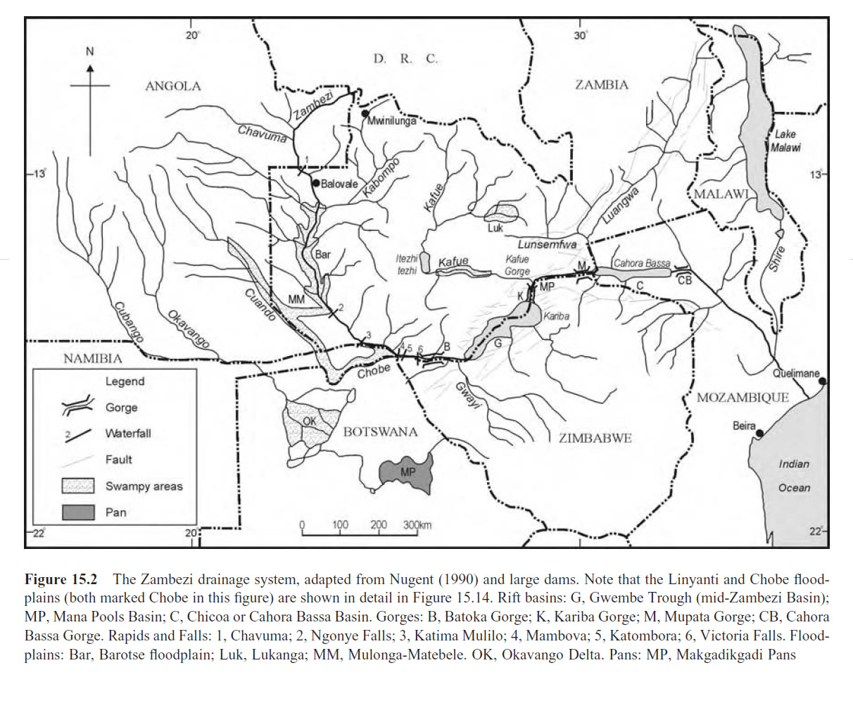
The Zambezi River drainage system (Moore et al, 2007)
[click image for larger view]
A River in Three Parts
The Zambezi is often divided by geographers into three regions comprising 13 sub-basins, each having a distinctive geomorphological unity (Wellington 1955). The Upper Zambezi extends from the headwaters to Victoria Falls and includes the Upper Zambezi, Kabompo, Lungwebungo, Luanginga, Barotse, and Cuando/Chobe sub-basins; the Middle Zambezi from the Victoria Falls to the edge of the Mozambique coastal plain, which commences below Cahora Bassa Gorge, includes the Kariba, Mupata, Kafue, and Luangwa sub-basins; while the Lower Zambezi, comprising the stretch traversing the coastal plain to its delta into the India Ocean, includes the Tete, Lake Malawi/Shire, and Zambezi Delta sub-basins (Moore et al, 2007; Belifuss, 2012)

The 13 major sub-basins of the Zambezi River Basin. Map produced by J.-M. Mwenge Kahinda, CSIR-South Africa. (Belifuss, 2012)
[click image for larger view]
“The Zambezi Basin can be divided into three major segments: the Upper, Middle, and Lower Zambezi, each with distinct geomorphological characteristics (Wellington, 1955). The Upper Zambezi segment extends from the headwaters to Victoria Falls. The Middle Zambezi segment extends from below Victoria Falls and flows through the Gwembe and Mana Rift Grabens, delimited by the deep, narrow gorges at Batoka, Kariba, Mupata and Cahora Bassa (Moore et al., 2009). The Lower Zambezi flows across the Mozambique coastal plain, extending from below Cahora Bassa Gorge to the Indian Ocean where its delta preserves a continuous, deep sedimentary record dating back to the Jurassic period (Moore et al., 2022).
“The river’s structure reflects repeated episodes of intracontinental rifting that have reshaped its drainage, yet remarkably, its primary channel and catchments have evolved from recognisable ancient precursors. The modern Zambezi flows across ancient landforms inherited directly from a Proto-Zambezi river on the Gondwana Supercontinent, and despite tectonic changes, this network has persisted since the end of the Dwyka glaciation in the Permian (Moore et al., 2012; 2022). Thus, the Zambezi is arguably the world’s oldest river (Key et al., 2015; Moore et al., 2022). The archaeological record preserved within the Zambezi Basin, particularly across the Zambian plateau and in the alluvial sediments above the Victoria Falls, attests to the importance of its wetland resources to human ancestors for at least the past 1 million years (Moore et al., 2022).” (Lourenço et al, 2025)
The Upper Zambezi Catchment
Belifuss (2012) gave a comprehensive overview of the hydrological character of the Upper Zambezi:
“The Upper Zambezi region (515,008 km2) includes two major landscapes, the Northern Highlands and the Central Plains. Deep, well-drained Kalahari sands cover the entire region (Balon and Coche 1974). The Northern Highlands consists of a belt of high ground on the south side of the Equatorial Divide that gives rise to the Zambezi and its headwater tributaries. From its origin near the Kalene hills in the far northwest corner of Zambia (elevation 1,370 m AMSL) the Zambezi winds through east-central Angola, capturing runoff from the Angolan highlands before reentering Zambia at Chavuma Falls. Farther downstream near the town of Lukulu, the Zambezi captures runoff from its two largest headwater tributaries, the Kabompo River of northwestern Zambia and the Lungwebungu River of central Angola.
"The steep channels and open terrain of the Northern Highlands drains rapidly, with minimal floodplain retention – runoff rises sharply with the onset of rainfall, peaks between February and April, and then rapidly recedes to minimal flows between September and November (Balek 1971a).
"Below Lukulu, the Northern Highlands give way to the broad flat plateau of the Central Plains. For the next 200 km, the Zambezi River meanders through the Barotse Plain, a vast floodplain grassland more than 40 km wide. During the rainy season, the floodplain is inundated by Zambezi floodwaters to form a large shallow lake that significantly attenuates Zambezi runoff. Peak runoff from the Northern Highlands typically reaches Lukulu during February-March, but Zambezi floodwaters take 4-6 weeks to pass through the Barotse Plain, and peak discharge downstream is often delayed until April or early May. Floodwaters recede slowly from the Barotse Plain during the six-month dry season, with high evaporation losses throughout the year.
"Downstream of the Barotse floodplain, the Zambezi traverses another vast floodplain system, the Chobe Swamps, that further attenuates runoff from the Zambezi and the Cuando/Chobe headwaters system (which drains central Angola through the Caprivi Strip of Namibia and northeastern Botswana). During the early part of the flood season, the Chobe River flows in an easterly direction from the Chobe swamps towards the main Zambezi channel, and may contribute substantial runoff to Zambezi system (Balek 1971b). As Zambezi levels rise, however, floodwaters spill from the Zambezi back into the Chobe swamps, and are lost through evaporation. Downstream of the Chobe River confluence, the Zambezi cascades over a series of basalt outcrops, including the Katambora Rapids, until plunging 98 m over Victoria Falls." (Belifuss, 2012)
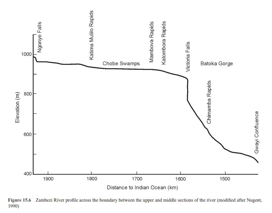
Zambezi River profile across the boundary between the upper and middle sections of the river (Moore et al, 2007)
[click image for larger view]
At the Victoria Falls the river markedly changes its character, ecology and typical flora and fauna. Lourenço et al, 2025, highlighted the differing nature of the Upper Zambezi compared to the lower stretches of the river.
“The Upper Zambezi segment is characterised by numerous streams and extensive wetlands and floodplains, in contrast to the more hydrologically regulated Middle and Lower Zambezi segments, which feature large-scale reservoirs and lakes (Beilfuss, 2012; Schleiss and Matos, 2016).” (Lourenço et al, 2025, p.4565)
The Upper Zambezi catchment, with a total area of 515,008 km2 is divided into six sub-basins:
Upper Zambezi 91,317 km2
Lungwebungu 44,368 km2
Kabompo 78,683 km2
Luanginga 35,893 km2
Cuando/Chobe 148,994 km2
Barotse 115,753 km2

Upper Zambezi sub-basins (adapted from Lourenço et al, 2025)
[click image for larger view]
The Batoka Gorge
Downstream of the Victoria Falls, and entering the section of the Middle Zambezi, the river is initially constrained within the narrow confines of the Batoka Gorge.
"Downstream of the Victoria Falls the Zambezi gorge follows a tight zigzag course for some eight kilometres, the general direction being to the south. This configuration is due to the repeated cutting back of the line of the Falls and the successive formation and abandonment of each of seven broad waterfalls, all broadly comparable with the present one. Beyond the confluence of the Zambezi and Songwe, at an impressive meeting of two nearly precipitous gorges which may be reached by road on the Zambian side, the main river turns again to a more easterly course. The gorge, here known as the Batoka Gorge, now becomes progressively deeper; its walls are more weathered and less steep, indicating its progressively greater antiquity...r.
"Throughout the 90-100 kilometre length of the Batoka Gorge the Zambezi drops approximately 260 metres from its level at the base of the Victoria Falls. Over this distance the top of the basalt rock through which the gorge has cut remains more or less horizontal; much of this drop is thus due to the progressively deepening of the gorge. This is some 110 metres deep at the Victoria Falls themselves; but at its downstream end the depth of the gorge approaches 350 metres. Although of such great depth, the gorge here is considerably weathered and lacks the precipitous walls of bare rock which are characteristic of its upper reaches. There are no major waterfalls in the gorge itself and consequently most of this drop is accounted for by several series of rapids. Only at Chimamba Rapids (called Moemba Falls by Livingstone) is there anything approaching a true waterfall in the gorge. Here, some 36 kilometres east of the Victoria Falls, the whole Zambezi passes through a defile less than twenty metres in width, best described in the words of G W Lamplugh:
"'Insignificant in height it is true, but when one stands on the brink of the lower cataract and sees the whole volume of the great Zambezi converging into a single pass only fifty or sixty feet in width, shuddering, and then plunging for twenty feet in a massive curve that seems in its impact to visibly to tear the grim basaltic rocks asunder, one learns better than from the feathery spray-fans of the Victoria Falls what force there is in the river, and one wonders no longer at the profundity of the gorge.' (Lamplugh, 1908, 150-1)." (Phillipson, 1990)
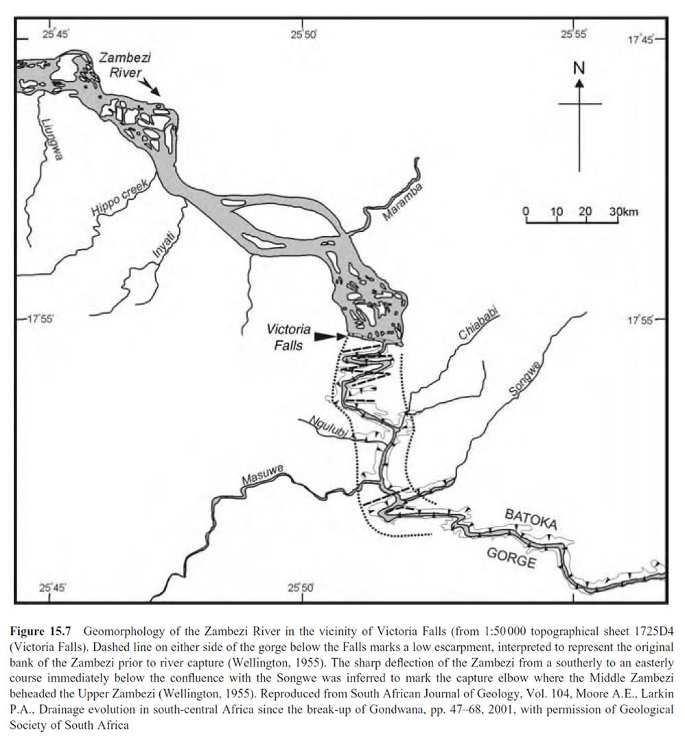
Geomorphology of the Zambezi River in the vicinity of Victoria Falls (Moore et al, 2007)
[click image for larger view]
Hydrological Factors
The average annual rainfall over the Zambezi basin is about 960 mm, but varies from more than 1,500 mm per year in the northern highlands to less than 600 mm per year in the low-lying south/southwestern portion of the basin (Belifuss, 2012). Rainfall is characterized by considerable seasonal and annual variation and the natural flow regime of the Zambezi River reflects these rainfall patterns and is also characterized by high seasonal and annual variability.
The Victoria Falls experiences the vast bulk of its annual rainfall in the hot summer months between November and March, however the flow over the Falls is derived from tributary sources upstream in the Angolan and Zambian headwaters to the north.
"Virtually all the rainfall in this region, which averages some 76 centimetres per year, falls in the five months between November and March. This summer rainy season is also the hottest time of the year, when temperatures can reach 52 degrees Centigrade it is, however, only when the rains are interrupted for several weeks that such extreme temperatures are experienced. Generally, the cool dry season of June and July has occasional night frosts and is followed by steadily increasing temperatures until October, which can be uncomfortably hot. The advent of the rains brings immediate relief and when the rains peter out in March or April temperatures are again falling."
"Since the bulk of the water which passes over the Victoria Falls is derived not from rainfall in their immediate vicinity but from that in regions far upstream, there is an appreciable time-lag between the season of peak rainfall and that of highest flow of water over the Falls. The Victoria Falls have their lowest water level generally in late November or early December, well after the start of the rainy season. At this period the mean flow of water over the falls is less than 20,000 cubic metres per minute; the clear steely blue water breaks into thin white veils and, since comparatively little spray is produced, it is at this season that the geological formation of the falls can most easily be appreciated. As the rainy season proceeds the water level rises rapidly and generally reaches its peak in March or April, although there is considerable variation in this from year to year. At peak flood, water passes over the Falls at about thirty times its dry season volume, averaging 550,000 cubic metres per minute." (Phillipson, 1990)
.jpg "Mean daily precipitation Upper Zambezi sub-basin")
Mean daily precipitation (Funk et al., 2015) across the Upper Zambezi sub-basin (adapted from Lourenço et al, 2025)
[click image for larger view]
The hydrological factors influencing the Zambezi and Falls were summerised by Moore et al (2007):
"The hydrology of the Zambezi catchment is determined by the interplay of a variety of factors. The annual variation of rainfall in summer is due to the Intertropical Convergence Zone between the North-east Monsoon and the South-east Trades for the Middle and Lower Zambezi, and the Congo air boundary between the South-west Monsoon and the South-east Trades for the Upper Zambezi. The further south the two boundaries move, the greater the total delivery of rainfall. In winter these two climatic boundaries move north, resulting in drier conditions across the Zambezi Basin. Rainfall by and large increases from south to north (600-1,300mm), so that the largest contribution to runoff comes from the northern tributaries.
"The hydrology of the Zambezi is further influenced by water exploitation by different users. The catchment as a whole is relative undeveloped so that off-take by irrigation, industrial and domestic users only amounts to some 3% of the total flow of the Zambezi. The use by hydro-electric power, due to the net evaporation from the large reservoirs of Kariba and Cabora Bassa Dams and, to a lesser extent, of the Kafue Gorge Dam, amounts to just over 5% of the Zambezi flow. However usage by these sectors is more than offset by the increased runoff due to changes in land use, particularly since the middle of the last century (Davies, 1986). Thus, for example, preliminary calculations based on research by the Wallingford Research Station on Lake Malawi (Price et al 1998) indicates that increased runoff caused by the clearing of natural forests in the Shire catchment has meant the level of Lake Malawi in the early 1990s was 1m higher than it would have been otherwise...
Moore et al (2007) calculated a mean annual flow for the Zambezi at the Falls of 1,171 m3 s-1 for the fifty year period 1951/2-2001/2). Mean monthly figures showed October/November lows under 300 m3 s-1 and an April peak of just over 3,000 m3 s-1.
Mean monthly flow (m3 s-1) Victoria Falls (1951/2-2001/2)
October - 293
November - 297
December - 438
January - 686
February - 1184
March - 2175
April - 3007
May - 2613
June - 1621
July - 845
August - 519
September - 376
"The annual variation in rainfall between dry winters and wet summers produce high flows in February-April and then progressively lower flows up to a November minimum. The annual flooding is however buffered by the natural flood regulatory capacity of the floodplains developed on the major headwater tributaries. The most important of these are the Barotse and Chobe floodplains in the upper Zambezi, the Kafue Flats on the Kafue River and Elephant March on the Shire River. Flow has been further affected by the construction of major dams in the Zambezi (Kariba and Cahora Bassa) and on the Kafue (Itezhi tezhi and Kafue Gorge).
"Records of water levels from the hydrological station at Victoria Falls, taken since 1907 are illustrated in F 15.11c. These indicate lower than normal years for 1907-1946, above normal for the years 1947-81, and again below normal for 1982-97. A major flood of 1958, during the construction of the Kariba Dam, followed heavy rains in the upper catchment and also the local catchment below Victoria Falls. In magnitude it was equivalent to the 1 in 100 year flood, which in turn is roughly half the probable maximum flood of 21,000 m3s-1. McCarthy et al (2000) tentatively interpret the variation in annual flows of the Zambezi to show an apparent oscillation between periods of good years and poor years in an approximately 80 year cycle.
"Long-term changes in the Zambezi flow regime are broadly mirrored in the Okavango River. Historical accounts of flooding of the Okavango Delta suggest average to above average outflows for the period 1849-1900, followed by limited outflow with some good years for the period 1900-1951. Outflow from the Delta for the 1960s and 1970s was above normal and the outflow for the 1980s and early 1990s below normal (McCarthy et al, 2000).” (Moore et al, 2007, p.317-320)
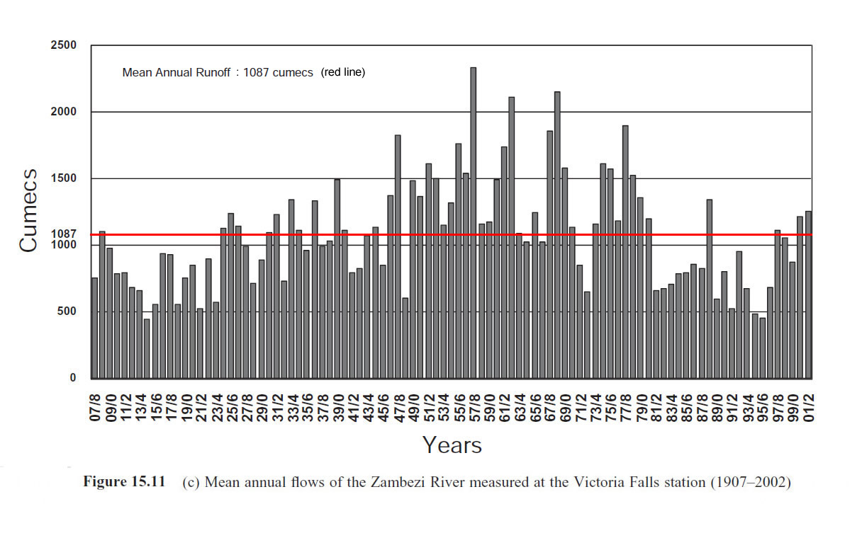
Records of water levels from the hydrological station (Fig 15.11c, Moore et al, 2007)
[click image for larger view]
The 2001 Victoria Falls Combination Plan recorded:
"Flows on the Zambezi River have been measured since 1907 and show a sequence of dry and wet periods. The period from 1907 to the 1920s was a dry period followed from the mid-1920s to 1947/8 by a normal period. From 1947/8 to 1979/80 there was a wet period (when mean annual flows were double those recorded in the initial dry period). The most recent period from 1980/1 to recent times has been a dry period. It would appear from the last two years that we might now have entered another wet sequence.
"The main river running into the Zambezi in the Plan Area is the Masuie. In addition, there are a series of nine springs that occur at the junction of the Kalahari Sands and the underlying basalts in the northern part of Zambezi [National] Park. They in turn lead into a series of vleis and short rivers that drain into the Zambezi. Since much of the Park road network passes through the basalt soils and crosses these vleis, any increase in tourist traffic will have to take into account increased road maintenance and the impact of road development on these wetlands. Any upgrading of these roads should include a re-alignment of roads away from sensitive wetland areas and eco-zones (World Bank project).” (Plan Afric, 2001, p.30-1)
A New Source (2025)
In late 2025, new research revealed the previously unrecognised significance of the Angolan headwaters as the dominant and geographic source of the Zambezi, identifying a new source of the Zambezi (as defined by the furthest distance from its mouth and contibutory volume of flow), the Lungwebungu River headwaters in Angola, located about 1,440 m (4,720 ft) above sea level, and also increasing the defined length of the river, at least by this definition (Lourenço et al, 2025). The total length from the Lungwebungu source to the Indian Ocean is 3,421 km, whereas the total length from the traditional or mainstem Zambezi source to the Indian Ocean is now calculated to be 3,079 km. According to the new study the traditional source ranked only 5th in length (the top three being the Lungwebungu, Luateche and West Lunga tributaries).
"Complementary definitions of the river source concept consider river length together with characteristics of individual tributaries, which represent respective hydrological attributes of the river system. In this respect, we provide evidence that the currently recognised source of the Zambezi River is not the longest tributary, ranking 5th in length. Empirical comparisons of river length track data and high-resolution digitisation reveal the Lungwebungu River is approximately 342 km longer than the traditionally recognised source. Originating in Angola, this river is the source of the Zambezi according to the criterion of river distance." (Lourenço et al, 2025)
The researchers concluded that at the time of their study (2023 flood season) the Angolan tributaries contributed some 70 pecent of the flow volume of the Zambezi over the Victoria Falls and entering Lake Kariba.
"Apart from a few ephemeral rivers and local rainfall, the Zambezi River receives no significant inputs between the Barotse floodplain and Victoria Falls (with the minor exceptions of the Cuando and Luanginga rivers, both of which originate in AHWT). Based on point-in-time measurements conducted during the late rainfall season between March and May 2023, we estimate that approximately 70% of the water entering the Kariba Reservoir, below Victoria Falls, originates in the AHWT. While preliminary, these initial findings suggest a potentially substantial Angolan contribution to downstream flows, with important but previously underappreciated implications for transboundary river management and policy." (Lourenço et al, 2025)
The dominance of the Angolan tributaries is perhaps not surprising considering 87% of the Upper Zambezi catchment lies within Angola:
"Although the traditional source of the Zambezi begins in the north-western corner of Zambia, the river enters Angola approximately 89 km (from recorded track data) downriver. The majority (87 %) of the Upper Zambezi sub-basin lies within Angola, where much of the precipitation occurs." (Lourenço et al, 2025)
Regime Regulators
The study emphasised the importance of the Upper Zambezi wetlands in water regulation and release:
"The Upper Zambezi and Okavango basins are key dry-season water sources for the Kavango-Zambezi Transfrontier Conservation Area (KAZA-TFCA), the world’s largest TFCA, which protects keystone regional wildlife populations (KAZA-TFCA, 2019). Pioneering assessments by White (1983), Jackson (1986), and others highlight the significance of the Zambezian Grasslands biome and the Upper Zambezi tributaries as some of Africa’s reservoir rivers, which exhibit minimal fluctuation in water levels due to the slow release of water. They provide vital hydrological functions (Jackson, 1986), supporting regional water security...
"These ecosystem services in tropical highlands are sustained by the extensive Kalahari sediment aquifer, which is mantled by extensive miombo woodlands, and particularly the groundwaterfed peatlands of the dambo floodplains of the Zambezian Grasslands biome. These natural sponges absorb, filter, and store water through the hot, wet season, to gradually release it into the river system over the dry season (Lourenco et al., 2022). Radiocarbon dating shows these peatlands have functioned for at least 7100 cal. yr BP (Lourenco et al., 2022), after the onset of the African Humid Period during the early Holocene (Shanahan et al., 2015), a testament to the long-term climate resilience of the AHWT. The AHWT maintains a vital buffer against the ecological and socio-economic impacts of the El Niño Southern Oscillation (ENSO) across south-central Africa (Timmermann et al., 2018; Cai et al., 2021). However, mining, deforestation and erosion would destabilise the natural buffering mechanisms and hydrology of the AHWT." (Lourenço et al, 2025)
References
Links to external sites or pdf downloads, open in a new window.
Beilfuss, R. (2012) A Risky Climate For Southern African Hydro - Assessing Hydrological Risks And Consequences For Zambezi River Basin Dams. International Rivers.
Lourenço, M, Boyes, R S, Cotterill, F P D, Flügel, T, Nyoni, F C, Ramatlapeng, G J, & Von Brandis, R. (2025) Assessment of source regions of the Zambezi river: Implications for regional water security. Hydrology and Earth System Sciences, 29(18), 4557-4583. (12.5 mb)
Moore, A E, Cotterill F P D, Main, M P L, and Williams H B. (2022) The Zambezi River. In Gupta, A [Editor] (2022) Large Rivers - Geomorphology and Management. Second Edition. Chapter 16. John Wiley & Sons, Ltd, England.
Phillipson, D. W. [Editor] (1990) Mosi-oa-Tunya: a handbook to the Victoria Falls region. Longman, Salisbury. (Second edition)
Plan Afric (2001) Victoria Falls Combination Mater Plan. Draft Report of Study (pdf download [36.6 mb], opens in a new window)