Keep Victoria Falls Wild
Conservation and Development of the Victoria Falls
Riparian Fringe
Boundary Infringements (MoTNP)
Conflicting Zones (MoTNP)
Island Developments?
Historical Developments Disclosed
Tourism Development Pressures
The following text has been adapted (with permission) from
researched and written by Peter Roberts and published in February 2026
Joint Strategic Assessment (2021-2030)
Twenty-five years after the first attempt to develop a joint regional strategy for the wider Victoria Falls area (IUCN,1996a; b; c) the State Parties finally published a new Strategic Environmental and Social Impact Assessment Report for the MOT/VF WHS (2021-2030) in August 2021, covering an area extending over a 30 km radius from the Falls. The document was produced by an independent consultant, Professor Imasiku Nyambe (Professor of Geology and Coordinator of the University of Zambia’s Integrated Water Resources Management Centre) and funded by the African World Heritage Fund (AWHF).
“While the 1995 SEA primarily focused on the analysis of tourism development and environment, the 2021-2030 SESA goes beyond by analysing the impacts of socio-economic issues (i.e. urbanization, increase in population, employment, energy demand, health) as well as climate change, ecology, geology, land use and hydrological issues. The anthropology and history of the people and developments in the area is also analysed. This report also highlights the impacts of changes, predicted scenarios and makes strategic recommendations to sustain the integrity of the Property.” (State Parties, 2021, p.3)
“The Study Area is having a radius of 30 km on each side of the Victoria Falls encompassing an Area of 2,800 km². It ranges from downstream of the Katombora rapids in the west to the fourteenth gorge in the south of the Zambezi River. The Area includes Livingstone City, part of Kazungula District and Victoria Falls town; as well as three National Parks namely - Mosi-oa-Tunya National Park, Zambezi National Park and the Victoria Falls National Park. It also includes traditional land in Zambia of Chief Mukuni, Musokotwane and Sekute and the communal lands of Hwange Rural District [in Zimbabwe, under Chief Mvutu, Shana and Hwange]. There is also significant forest land on both sides...
“The three National Parks cover a wider area than the World Heritage Site and the legal protection in these areas is the same. This prohibits any permanent development but allows access with minimum management interventions. Hunting, cutting of trees, stone cropping or removal of dead wood is strictly prohibited.” (State Parties, 2021, p.21-2)
The document is heavily weighted towards to north bank, reflecting limited input from Zimbabwean authorities in the production of the document.
Riparian Fringe
The Plan recognised the ecological and conservation significance of the ‘riparian fringe.’
“The area surrounding the Victoria Falls is classified as tropical dry or deciduous forest and woodland in the afro-tropical realm. The predominant woodland type is Kalahari woodland, which grows on the overlying Kalahari sands. The Zambezi River runs through the middle of the area and creates its own special riverine biome which is distinct from the general biome classification. Upstream, this forms a wide, shallow river valley with riverine forest and many islands. At the Victoria Falls itself the Zambezi River has cut the underlying basalt rock to form a series of gorges over 100 meters deep from the main level of the land. The river becomes narrow and confined within the steep cliffs. The narrow rocky banks, feeder streams and gorges also have a distinctive habitat.
“The Victoria Falls are of unique geology, geomorphological and aesthetic value. They are one of the most spectacular waterfalls in the world with a curtain of falling water 1,708 m wide and 108 m deep. The zig-zig course of the gorge downstream, caused by successive erosion through the weakest faults in the basalt, enable viewers to see the Falls for their complete length from the opposite bank at a distance of less than 100m. The surrounding National Parks contain flora and fauna representative of the area but by no means unique. The woodland types surrounding the area are very characteristic, but the riverine forest above the Falls is unique, especially the area kept moist by the spray from the Falls, also known as the ‘rain forest.’” (State Parties, 2021, p.22)
Boundary Infringements (MoTNP)
The plan presented a map of the north bank MoTNP showing the 2006 boundary changes, pressures from human settlements bordering the park (and WHS), as well as highlighting areas of encroachment into the park. The map indicates that the issue of private land ownership within the area of the Maramba River, and overlapping into the park (and WHS) has yet to be resolved. The map also indicates a further area of encroachment surrounding the ZESCO (Victoria Falls Power Station) facilities located above the junction of the third and forth gorges (State Parties, 2021, p.64).
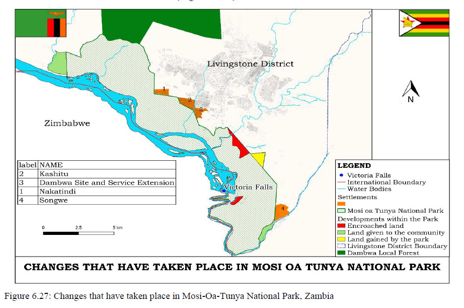
Map of MoTNP showing boundary pressures (areas of encroachment marked in red)
(State Parties, 2021, p.64) [click image for larger view].
Conflicting Zones (MoTNP)
The plan also presented a revised map of management zones within the MoTNP (State Parties, 2021, p.65, dated May 2021), as well as a map of the joint WHS management zones (State Parties, 2021, p.80). The WHS map again presented the wider ZNP as representing the Buffer Zone, resulting a reduction in the scale of the map and reducing the detail in regard to the WHS itself. Notably the two maps appear to show different management zones for the MoTNP and north bank WHS.
The map accommodates the north bank changes to the MoTNP made in 2006, and correctly shows the south bank upstream ZNP section as within the WHS HESZ. The scale of the map is insufficient to show the detail along the south bank upstream VFNP section. While restoring the full extent of the upstream river corridor, the map fails to show significant upstream islands as within the HESZ, while instead highlighting some areas of the open river as within the HESZ and making it difficult to distinguish the line of the riverbank (the whole of the river and all islands within the upstream section should be included within the HESZ).
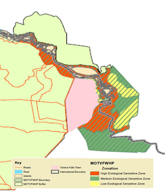
Map showing World Hertiage Site management zones
(Adapted from State Parties, 2021, p80
[click image for larger view].
Island Developments?
It is perhaps also significant that under ‘Recommendations for islands on the river’ the document records, among various other suggestions:
“Consider no developments on islands within the World Heritage Site.” (State Parties, 2021, p.130)
As with the map, the State Parties are failing to acknowledge, or accept, that all the upstream islands within the WHS are already within the HESZ ‘no new development’ zone. No new developments are permitted on any of the islands within the WHS upstream river corridor.
Historical Developments Disclosed
The Plan included a map showing tourism infrastructure developments on the south bank (State Parties, 2021, p.127), finally disclosing the locations of many developments within the WHS which had, to this date, not been specifically disclosed to UNESCO (Victoria Falls River Lodge, Old Drift Lodge and Wild Horizons Lookout Cafe and Estate developments), although there is no supporting text or details. The map does not include the long established A’Zambezi or recently announced Palm River Lodge.
The Plan gave no indication of any new/planned developments within the WHS, such as the developments along Zambezi Drive and Kandahar Camp (note there is no number 8 on the list), or the significant Masuwe development plans.
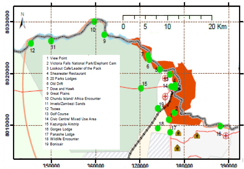
Map showing south-bank tourism developments
(Adapted from State Parties, 2021, p.127). [click image for larger view].
Tourism Development Pressures
The document appears to accept that increasing tourism development pressures have led to the ‘need’ to develop tourism infrastructure within the WHS, as well as the surrounding area.
“Tourism receipts and activities have been increasing around Victoria Falls on both sides. This has seen a rapid increase in the demand for development land as tourism business and investments increase. This has prompted the need to develop tourism accommodation, amenities and service infrastructure such as hotels and lodges within the World Heritage Property (WHP), its buffer area and within the 30 km radius.” (State Parties, 2021, p.80)
The document then goes on to detail negative impacts on the WHS while seemingly accepting development pressures as inevitable. Under ‘Habitat loss, fragmentation, and degradation’ the document states (in relation to the north bank):
“Tourism expansion, deforestation, pollution and invasive species are some of the ways in which ecosystem processes are disrupted. The potential for tourism expansion in the study area is high and likely to bring benefits to the city [Livingstone] and the community if well managed and marketed. However, the expansion has to meet some ecological and socio-economic requirements to be viable, acceptable and successful. It is therefore a priority conservation effort to revegetate the Site by way of planting trees.” (State Parties, 2021, p.89)
It is also perhaps notable that under ‘Planning and Management’ the document states: “As tourist numbers grow, protection will have to be increased” (State Parties, 2021, p.130), before listing a series of infrastructure developments aimed at facilitating tourism, while not identifying any increased protections for the site.
The report highlighted the ongoing use of the 1975 Outline Plan as the major planning guide to development on the south bank, supported by bylaws limiting building height to within the surrounding tree-canopy height (identified at 11 metres).
“Victoria Falls City is still using the 1975 Outline Scheme as the major guiding legislation and also using Section 49 of the Regional Town & Country Planning Act, Chapter 29; 12 of 1996 for change of reservation applications. It has also adopted the building bylaws to curb unsustainable development for example maintaining tree height as the maximum building heights (VFM, 2017).” (State Parties, 2021, p.71)
Next: Monitoring Mission (2022)
References
Links to external sites or pdf downloads, open in a new window.
Roberts, P. (2026) Paradise Lost? Conservation and Development of the Victoria Falls (1900-2025). First Edition, February 2026. Zambezi Book Company / CreateSpace Independent Publishing.
State Parties (2021) 2021-30 Strategic Environmental and Social Impact Assessment Report, Victoria Falls World Heritage Property (pdf download [9 mb], opens in a new window)