Keep Victoria Falls Wild
Conservation and Development of the Victoria Falls
The 1975 Victoria Falls Outline Plan
Planning for the Future (South Bank, 1970s)
The Outline Plan (South Bank, 1975)
Permanently Protected
The following text has been adapted (with permission) from
researched and written by Peter Roberts and published in February 2026
Planning for the Future (South Bank, 1970s)
In 1972 the Victoria Falls Management Board was upgraded to a Town Council under the new Urban Councils Act, giving increased local governance over a wide range of services. The same year the Land Tenure (Description of Boundaries) Notice (Rhodesia Government Notice No.1051 of 1972) redrew the boundaries of the Victoria Falls National Park, opening up a significant expanded wedge of Council controlled land, covering approximately 2,212 hectares (22 km²), extending north to the river above the Falls and southwards to the Masuwe River, as part of plans for the managed future growth and development of the town.
The Victoria Falls National Park, covering a total of 57,300 hectares (573 km²), was subdivided into two subsections by the road and rail transport corridor which crosses the Victoria Falls Bridge, the smaller downstream ‘Area A’ (covering 1,900 ha/19 km²) including the river and gorges extending some 16 kilometres downstream of the Falls, and ‘Area B’ (covering 55,400 ha/554 km²) including the Falls visitor park (the ‘Rainforest’). the western end of the Falls and river corridor extending 6 km upstream of the Falls (including a narrow section of the riverine fringe), before expanding into the greater part of the protected area, extending some 40 km upstream. Developments within the larger, upstream section of the Park, later to be renamed the Zambezi National Park, included a riverside drive and growing network of scenic roads.
The Outline Plan (South Bank, 1975)
In October 1972 a Victoria Falls Planning Scheme Area was gazetted by Government Notice 1622. The key task of the Planning Authority was to produce an Outline Plan for the management of the Falls environment, with the aim of preserving the natural environment of the Falls and to enhance the tourist potential of the area without detracting from its natural aspects. The Plan focussed on the Council controlled area but in order to give added protection also included the area of the Victoria Falls National Park covering the river immediately upstream and downstream of the Falls.
“In October 1972 a Victoria Falls Planning Scheme Area was gazetted in terms of Rhodesia Notice 1622. The main objectives were:
1 - to preserve the magnificent natural environment of the Falls
2 - to ensure that future development took place in a co-ordinated and harmonious manner
3 - to enhance the tourist potential of the area without detracting from the natural attractions
4 - to ensure the best use made of all land within the scheme area.</p>
"To administer the Scheme Area a Victoria Falls Planning Authority was established. This comprised 4 Town Councillors, 1 representative of the Rhodesia National Tourist Board, 1 representative of the Historical Monuments Commission and 1 representative of the National Parks Advisory Board. As a result of the declaration of the scheme area, no person could erect, alter or add to any building or alter the character of the land within the scheme area without obtaining the approval of the Victoria Falls Planning Authority. The key task of the Planning Authority was to produce an Outline Plan for the area. This was to be undertaken by the Town Planning Department. The Plan was prepared and placed on public deposit in January 1974. Modifications to the Outline Plan were made in 1975 following objections and a local inquiry.” (Plan Afric, 2001, p.14)
The Outline Plan, drafted in 1973 and published at the beginning of 1974 was approved with modifications under Executive Council Minute No 252/75 dated 2nd June 1975. The plan defined zones within the Council controlled area for hotel and tourism, industrial, commercial and residential development, as well as identifying proposed areas of future expansion.
“Proposed expansion areas include Sprayview airfield, and the State land to the South West of the town. Future expansion of the town is constrained by the National Park boundaries.” (IUCN, 1996a, p.24)
Permanently Protected
Under the agreed plan the natural areas extending east of the town down to the Falls, and upstream between the line of the road and river, were identified as Public Open Space, ‘restricted permanently’ from further development (with the exception of existing development and infrastructure essential for the administration of these areas). The protected zone included the land within the ‘Railway Loop,’ down to the Falls and extended upstream covering all the land from the proposed realigned route of Park Way north and east towards the upstream river section and including the area of the Elephant Hills Hotel and Golf Course (designated as Private Open Space) and stretching up to the A’Zambezi Hotel.
Key features of the Plan were detailed by Heath in 1977, quoted directly from the Victoria Falls Outline Plan Written Statement (Rhodesia Ministry of Local Government and Housing, 1975):
“i) A greatly increased area allocated for the African township.
ii) The Railway Reserve reduced in size.
iii) The original township area, which did not prove popular as residential land, designated as a light industrial zone.
iv) Government and local authority areas are located around the police camp.
v) Business areas are allocated on old residential stands to the north of the police camp on what were formerly the north-eastern portion of the railway reserve.
vi) The northern residential area has been enlarged and it is planned to use the site of the original aerodrome [Sparyview] for residential purposes.
vii) Areas allocated for tourist accommodation have been clearly defined.
viii) An attempt has been made to contain the area allocated for tourist amenities on the banks of the Zambezi upstream from the Falls.
ix) Areas designated as public and private ‘Open Space’ in the vicinity of the Falls and the Zambezi river are restricted permanently against building development, with the exception of buildings which are essential for the administration of these areas.” (Heath, 1977)
The Plan identified a total of 905 ha (9 km²) as ‘Public Open Space’ as being restricted permanently from development. To give added protection this area also included the section of the VFNP covering the river and islands stretching 6 km upstream and extending downstream from the Falls. An additional 121 ha (1.2 km²) of Private Open Space (Elephant Hills Golf Course) was also identified as permanently protected from further development (Heath, 1997, quoting Rhodesia Ministry of Local Government and Housing, 1975).
Another significant area of land, covering 445.5 ha (4.4 km²), was designated as ‘Rural,’ including important natural areas extending north-west of the town towards the river and upstream section of the Victoria Falls National Park.
“In effect this designation was designed to prevent development within the plan period but not according it strong protection as in the case of land designated protected Open Space.” (Plan Afric, 2001, p.85)
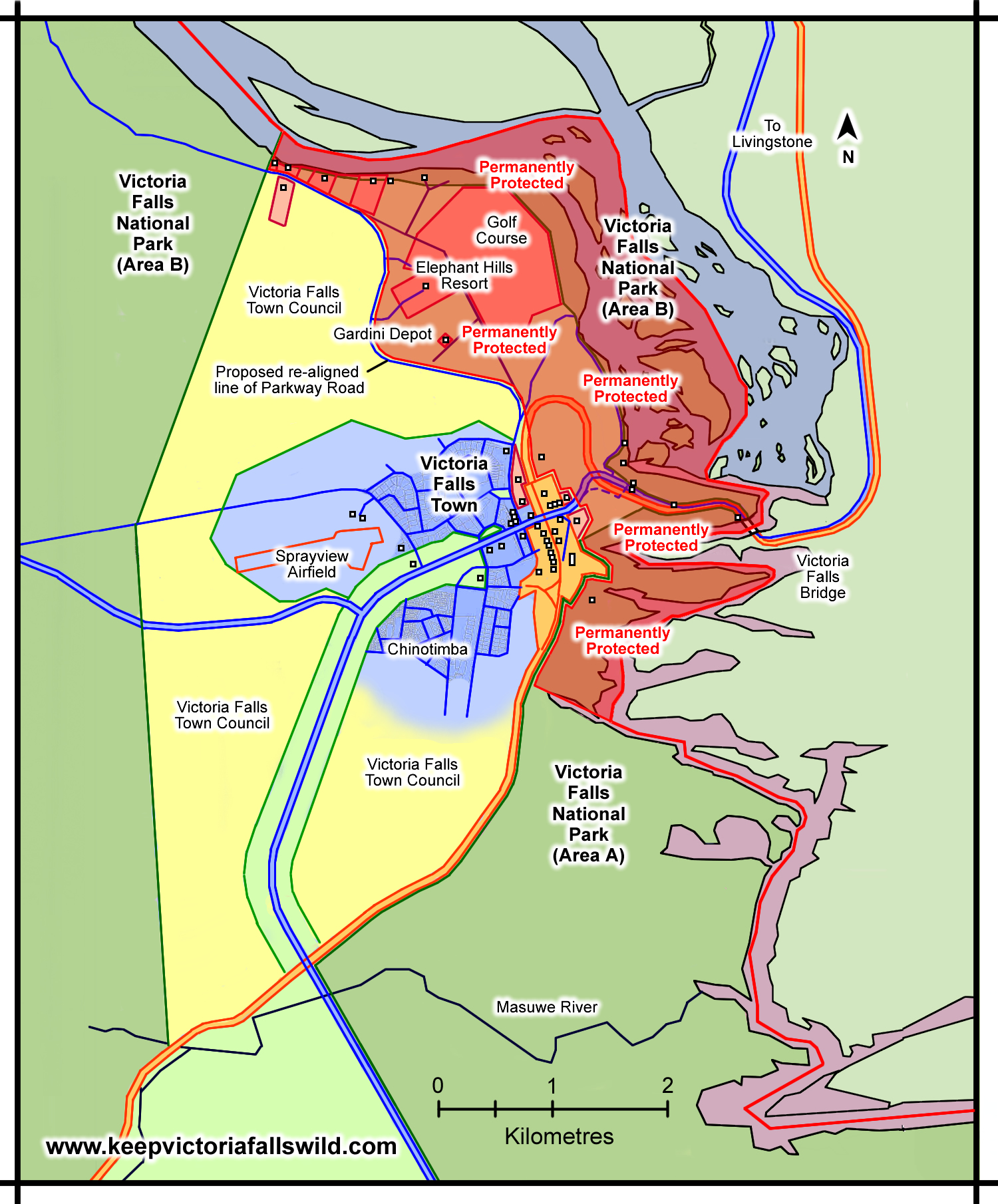
Map showing expanded Council-controlled area and management zones under the 1975 Plan (area restricted from development shaded red, ‘rural’ land in yellow), together with developments at the Victoria Falls, mid-1970s
(Adapted from Plan Afric, 2001)
[click image for larger view].
Other significant features of the Outline Plan included the creation of an open space ‘buffer zone’ of approximately 200 metres either side of the main road into the town, Livingstone Way. In 1973 the developed area of the town was estimated to cover 310 hectares (3.1 km²) of which 264 ha (2.6 km²) were built over (IUCN, 1996b, p.59). Heath recorded the population of Victoria Falls Town in the mid-1970s at around 3,000, and highlighted growing tourism pressures.
“The rapid growth of Victoria Falls during the last decade has caused considerable planning problems. It is of paramount importance that the immediate vicinity of the Falls should be altered as little as possible if its natural qualities are to be preserved. Conservation needs, however, may conflict with the need to provide facilities for tourists and in recent years there has been a proliferation of tourist services along the river bank upstream from the Falls...
It is only with the changing political and economic circumstances of the past decade that rapid growth has occurred and with it the necessity for a formal development plan. The rate of growth may well decrease in the future but the village is likely to continue to grow as visitors continue to be attracted to the Falls. The 1973 plan will, hopefully, control and contain future development and minimise the environmental impact of tourist activities. It would be unfortunate if the trend, which has characterised the village throughout this century, of planning reflecting individual enterprise rather than guiding and controlling it, should be allowed to continue.” (Heath, 1977)
Discover more details on the 1975 protected area under the 1996 IUCN Plan and the
2001 Combination Plan.
Next: Independence
References
Links to external sites or pdf downloads, open in a new window.
Heath, R. A. (1977) Victoria Falls. The Growth of a Rhodesian Village Proceedings of the Geographical Association of Rhodesia. No.10, p.15-29. [pdf]
IUCN (1996a) Strategic Environmental Assessment of Developments Around Victoria Falls, Executive Summary. IUCN Regional Office for Southern Africa.
IUCN (1996b) Strategic Environmental Assessment of Developments Around Victoria Falls, Volume 1: Strategic Environmental Assessment Report. IUCN Regional Office for Southern Africa.
Plan Afric (2001) Victoria Falls Combination Mater Plan. Draft Report of Study (pdf download [36.6 mb], opens in a new window)
Rhodesia Ministry of Lands (1970) The Matetsi Committee Report 1969. Ministry of Lands, Salisbury, Rhodesia, November 1970.
Rhodesia Ministry of Local Government and Housing (1975) Victoria Falls Outline Plan, Written Statement. Victoria Falls Planning Scheme Area. Ministry of Local Government and Housing. Department of Physical Planning.
Roberts, P. (2026) Paradise Lost? Conservation and Development of the Victoria Falls (1900-2025). First Edition, February 2026. Zambezi Book Company / CreateSpace Independent Publishing.