Keep Victoria Falls Wild
Current Threats
Victoria Falls City Council (Zimbabwe)
Big Tree Area Developments
Big Tree Curio Market (2023)
Golf Course Restaurant
Wildlife Corridor (2024)
Double Protection
Big Tree Area Developments
The line of Zambezi Drive road, after its turning off from Park Way and running down to the river, forms the boundary of the Victoria Falls National Park and World Heritage Site on the right, and Council-controlled land to the left. The area of natural wooded scrub to the left is further bounded by the Elephant Hills Golf Course. This area was designated as 'restricted permanently' from all new infrastructure development under the 1975 Outline Plan.
Big Tree Curio Market (2023)
The Big Tree, a large baobab tree located along Zambezi Drive, has long been an attraction for visitors and informal curio vendors looking for a chance to sell their wood and stone carvings.
The Big Tree Curio Market was formalised in 2017 with 30 members, growing to over 70 members before the outbreak of the pandemic and is now left with about 30 members (Victoria Falls Bits and Blogs, June 2022).
There has been no notification of this development to UNESCO, and no mention in the recent State of Conservation Reports or Joint Integrated Management Plan.
Satellite images from early 2023 show the development of temporary structures and removal of bush and scrub over a concentrated area around the parking layby opposite the tree.
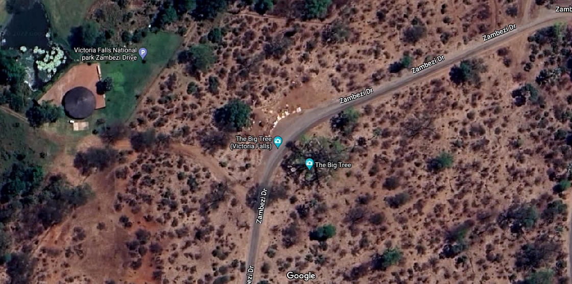
Big Tree Curio Market location [click for larger view]
At a National Park planning meeting, held with local stakeholders at the Victoria Falls in May 2022, concerns were raised over the inappropriate development of this curio market - especially as there are no toilet facilities, leading to obvious implications (ZPWMA, May 2022).
Media reports in March 2023 identified Across Zimbabwe Pvt Ltd as being involved in the formalisation of this market area (see Visitor Car Park developments). Mr Muleya, director of Across Zimbabwe indicated "we have 120 curio vendors operating under Across Zimbabwe at the Big Tree where we are working on repairing the shade." (Victoria Falls Bits and Blogs, 1st April 2023).
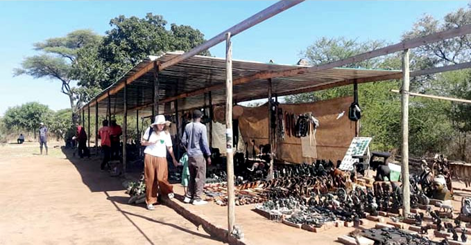
Big Tree Curio Market (May 2023)
Golf Course Restaurant
In recent years a new access road has been development to give access from Zambezi Drive to small pre-existing development within Elephant Hills Golf Course, with plans to expand this facility as yet another tourist restaurant development.
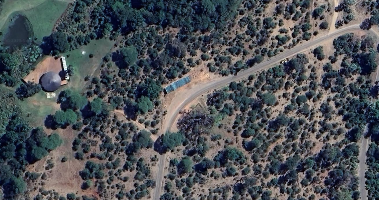
Elephant Hills restaurant and Big Tree Curio Market location (2023)
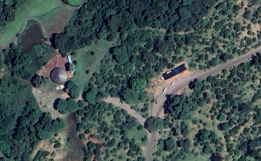
Elephant Hills restaurant and Big Tree Curio Market areas (mid-2025)
Wildlife Corridor (2024)
The area between Zambezi Drive and the Elephant Hills Golf Course is of local ecological significance, being dominated by Acacia and supporting a variety of different bird and other species associated with this ecotone and which are not found within the wider area. It is therefore of significant local conservation importance. The area is included within the ‘Open Space’ designation under the 1975 Outline Plan (and identified as Area 7 in the 2001 Combination Plan) which identified the area ‘restricted permanently’ from development, as well as being within the WHS 500 m Buffer Zone.
The Victoria Falls City Council 2024 Council Master Plan Draft Report of Study (VFCC, April 2024) identified this area as one of three key wildlife movement corridors (Corridor 2).
"2 - Big Tree. Again this is a vital but threatened link to the Zambezi River for elephants coming from the Zambezi NP past the Victoria Falls Safari Lodge. New developments in the World Heritage riverine areas are further restricting river access." (VFCC, 2024, p.67)
The Report further clarified in several additional statements that development pressures were directly impacting on wildlife movement with implications for human-wildlife conflict and emphasised the need to recognise and respect wildlife corridors in reducing people-wildlife conflict.
“Tourism and residential developments are affecting wildlife corridors and dispersal areas and this has a knock-on effect with human-wildlife conflict.” (VFCC, April 2024, p.155)
“As restrictions of wildlife movement increase the potential for human-wildlife conflict increases significantly.” (VFCC, April 2024, p.91)
“Need for Management of Wildlife and Human conflict - the Master Plan must recognise and accommodate wildlife corridors.” (VFCC, April 2024, p.204)
The 2024 Victoria Falls City Council Master Plan 'prefered option' map (VFCC, November 2024a) shows a new tourism development zone covering the whole of the area between the southern boundary of the Elephant Hills Golf Course and Zambezi Drive road (and boundary of the World Heritage Site).
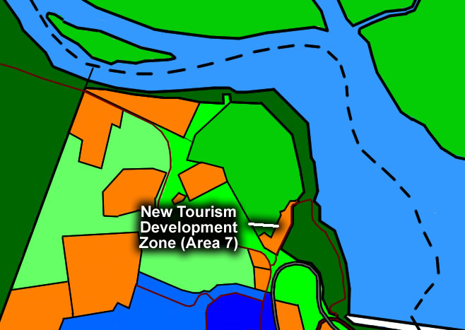
Northern part of the Council-controlled area showing tourism developments including area of the proposed new tourism development between golf course and Zambezi Drive Road (adapted from Victoria Falls City Council Master Plan, 2024) [click for larger view]
The Council's plans to develop this area, together with further riverside tourism stands (such as the Victoria Falls Resort proposal, the 'Stand 1815', Railway Loop and Road Loop), combined with National Park plans to develop the Elephant Hills riverine fringe for tourism under the Six Senses 'tree lodge' proposal, appear to be in direct conflict with the warnings and recommendations in the Council's own Report. Development of these areas can be predicted to lead to significant displacement of local elephants from traditional refuge areas and movement corridors, with a corresponding increase in people-wildlife conflict on both sides of the river the most likely consequence.

Area of Elephant Hills Golf Course and Zambezi Drive Road (2025)
Double Protection
The area of the Big Tree developments is permanently protected against development. The area is located within the wider no develeopment zone, designated under the 1975 Victoria Falls Council Outline Plan, which designates zone extended between the town and river, including the area of the National Park, as 'restricted permanently' from all new development.
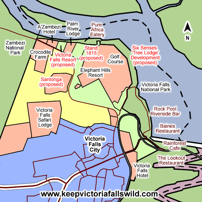
Map showing location of the proposed Palm River Hotel development. (click image for larger view).
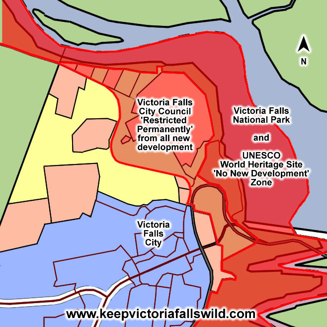
Map showing protected area, restricted permenantly from all new development, including the World Heritage Site. (click image for larger view).
Google maps: -17.912263, 25.841103 (external link, opens in a new window).
See also the Riverside Tree Lodge proposed development along the riverside fringe surrounding the Elephant Hills Golf Course.
References
Links to external sites or pdf downloads, open in a new window.
State Parties (2016) 2016-2021 Victoria Falls/Mosi-oa-Tunya Joint Integrated Management Plan (external download, opens in a new window).
Victoria Falls Bits and Blogs (17th June 2022) Vendors find home at Vic Falls’ Big Tree curio market.
Victoria Falls Bits and Blogs (1st April 2023) Victoria Falls US$5 car park opens.
Victoria Falls City Council (April 2024) Victoria Falls City Master Plan. Draft Report of Study. April 2024. (pdf download [34.3 mb], opens in a new window).
Victoria Falls City Council (June 2024) Victoria Falls City Master Plan. Written Statement. June 2024. (pdf download, opens in a new window).
Victoria Falls City Council (November 2024) Main Map (Preferred Option VF/MP/01, undated) and Supporting Map VF/MP/02 (undated) (insert section)