Keep Victoria Falls Wild
Existing Developments
Zambezi National Park (Zimbabwe)
Map Manipulations
A small section of the Zambezi National Park is included within the boundaries of the UNESCO World Heritage Site upstream river corridor.
The area is acknowledged as within the WHS in the 2007 Joint Integrated Management Plan text description of the site:
"A riverine strip of Zambezi National Park extending 9km west along the right bank of the Zambezi and islands in the river are all within the Park as far as Palm and Kandahar Islands. 17°55'S, 25°50'E.” (State Parties, 2007, p.14)
The description continues "a riverine strip of Zambezi National Park, 741 ha." (State Parties, 2007, p.14).
The 2007 document presents two maps of the WHS, the first (produced by the African Wildlife Foundation) correctly shows this area as within the WHS, but the second, notably, incorrectly excludes this area, including only the area of the river, and not the supporting section of the riverine fringe.
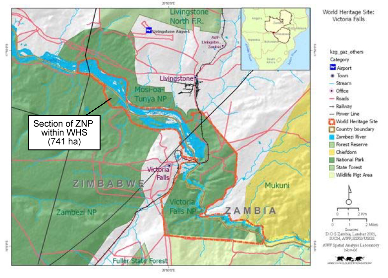
2000 African Wildlife Foundation map showing the boundary of the Victoria Falls World Heritage Site (State Parties, 2007). Note the area of the south bank Zambezi National Park.
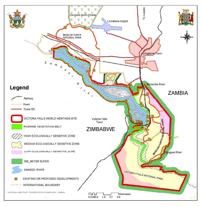
2007 map showing the Victoria Falls WHS as presented in the 2007-2012 JIMP. Note removal of upstream area of Zambezi National Park on southern bank (State Parties, 2007).
The supporting description of the management zones within the WHS makes no direct reference to the Zambezi National Park, but clearly places the riverine fringe within the 'Highly Ecologically Sensitive Zone' which prevents all new development:
"High Ecologically Sensitive Zone - ...Extent in Zimbabwe: The Falls; Zambezi river and all Islands upstream of the Falls up to Kandahar Island; Gorges up to 16th cataract; Riparian vegetation and the Rain Forest." (State Parties, 2007, p.39)
The exclusion of this area from the map appears to have been an intentional attempt to remove this area from the WHS, while the text description of the management zones appears to also be deliberately vague with the same aim.
In 2012 this area saw the development of the Victoria Falls River Lodge, with no notification to UNESCO.
In the 2016 Joint Integrated Management Plan the State Parties again presented two maps which exclude this area from the WHS, attempting also to remove a significant section of the upstream river corridor. The revised management zone descriptions again does not make any direct reference to this area of the ZNP (State Parties, 2016). There was no supporting explanation or justification for the changes presented within the document, leading to the conclusion that the changes were a coordinated attempt at manipulating the WHS boundaries to allow tourism developments without notifying UNESCO.
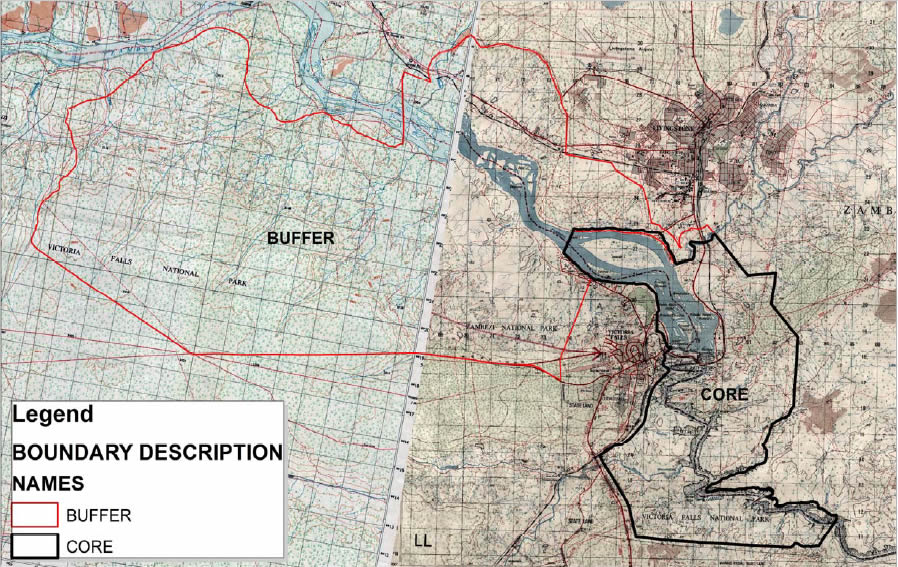
Amended map of the Victoria Falls World Heritage Site submitted as part of the 2016-2021 JIMP. Note the significantly reduced stretch of river corridor (and that the two halves of the map do not even match up correctly, distorting the river). (State Parties, 2016, p.15)
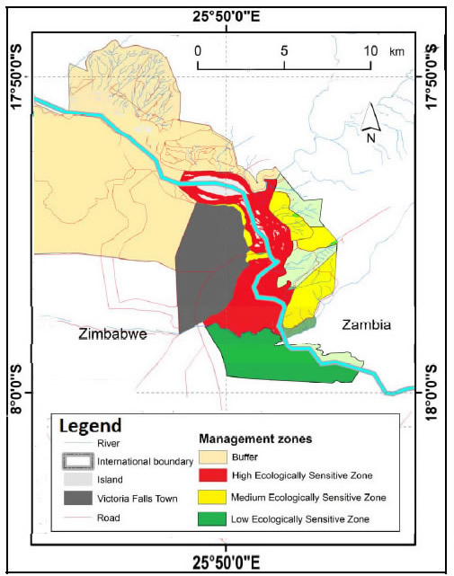
Map of the Victoria Falls World Heritage Site management zones submitted as part of the 2016-2021 JIMP. Note the significantly reduced stretch of river corridor. (State Parties, 2016, p.27).
This area of the ZNP riverine fringe saw the development of second tourism lodge with the opening of the Old Drift Lodge in 2018. Again there appears to have been no notification to UNESCO of this development.
UNESCO subsequently reminded the State Parties that the area of the WHS was as originally inscribed on the World Heritage List, and that any changes to the boundaries of the WHS needed specific due process.
“The State Parties are proposing to reduce the property’s boundaries, mainly by removing the northernmost part, including the Siloka Island and its immediate waters of the Zambezi River. This would reduce the property from 6,860 ha (approved via Decision 36 COM 8E) to approximately 6,562 ha. While purporting to respond to the recommendation of the Bureau of the Committee at the time of inscription in 1989, this is a notable reduction in the area compared to how the property has been managed since inscription and is presented in the approved Management Plan for 2016-2021. The visual setting of this property is central to its OUV and any reduction to the existing boundaries could significantly weaken the property’s integrity by possibly allowing further developments in the high ecologically sensitive zone. It would also be important to understand the rationale and motivations to reduce the boundaries. Given the visual and experiential sensitivities of the property, such a change cannot be approved within the process of the boundary clarification and retrospective inventory of the property but should be considered through a request for boundary modification as per the Operational Guidelines.” (World Heritage Committee, 2019)
The area was subsequently confirmed as being within the HESZ 'no new development zone' in a map presented in the 2024 National Park Management Plan (Zimbabwe Parks and Wildlife Management Authority, 2024).

Map showing proposed (amended) boundary and management zones
for the Victoria Falls World Heritage Site. From 2024 Victoria Falls/Zambezi National Park Management Plan, p.22. (click image for larger view).
We conclude that the small section of the ZNP riverine fringe, covering 741 ha, has always been within the HESZ 'no new development' zone of the Victoria Falls World Heritage Site and that the Victoria Falls River Lodge and Old Drift Lodge have both been constructed within the WHS HESZ without disclosure to UNESCO. Maps presented to UNESCO in the 2007 and 2016 JIMP documents have been purposely manipulated to cause confusion and create the incorrect impression that this area was not part of the WHS.
Existing Developments
Zimbabwe's National Parks were originally designated as 'no permanent development' zones, with adjoining Safari Areas set aside for either consumptive tourism (hunting) or commercial concessions and leases such as tourism camps and lodges.
Overnight facilities for visitors to the Zambezi National Park originally included three dedicated Fishing Camps (Kandahar, Siansimba, and Mpala Jena) with flushing toilet, cold shower and sleeping shelter, and four 'minimum development' picnic camps (Chundu 1, Chundu 2, Chomunzi and Saminungu) with braai stand and bush toilet, all suitable for groups up to twelve people. Over the last decade, however, there has been a steady trend in the licensing of these public campsites as private concessions, with tourism companies developing exclusive luxury safari lodges. Ten years ago there were no private concessions within the Park.
Tourism developments in Zambezi National Park are listed running upstream from main riverside Park entry gate, 6 km above Falls. The first 9 kilometres of river corridor and riverside fringe (741 ha) upstream from the main Park gate is included within the core area of the Victoria Falls World Heritage Site.
Within area of UNESCO World Heritage Site:
Old Drift Lodge (opened 2018).
Victoria Falls River Lodge (opened 2012).
Upstream of UNESCO World Heritage Site:
Siansimba Lodge (opened 2022).
Mpala Jena Camp (opened 2019, redevelopment of Pioneer's Camp, opened 2013).
Tsowa Island (opened 2019).
Chundu Island (opened 2017).
Zambezi Sands River Lodge (opened 2014).
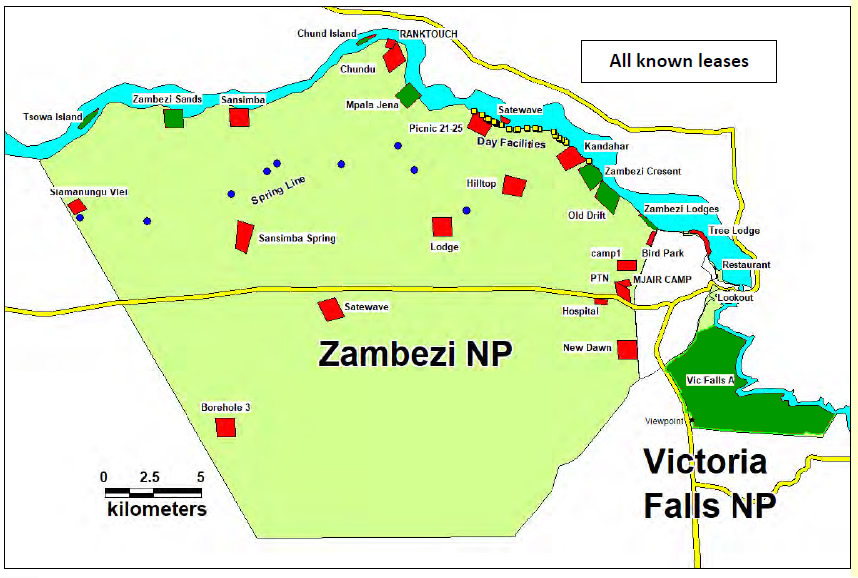
Map showing tourism concessions within the Zambezi and Victoria Falls National Parks
(existing - green, proposed - red)
(adapted from 2024 Victoria Falls/Zambezi National Park Management Plan, p.23)
[click image for larger view].
See here for proposed developments within the Zambezi National Park riverine corridor.